
Druid path
| Druid path | |
|---|---|
 Landmark |
|
| Data | |
| length | 6.7 km |
| location | Saarlouis district |
| Markers |
 |
| Start / finish point | Waldparkplatz Höllberg, diversion of the Neunkircherstrasse at the local end to the right, 66780 Niedaltdorf 49 ° 20 '45.1 " N , 6 ° 34' 32.5" O |
| Type | Circular hiking trail |
| Height difference | 100 m |
| The highest point | 258 m above sea level NN |
| Lowest point | 185 m above sea level NN |
| Level of difficulty | easy |
| season | All year round |
| particularities | Celtic barrows, mardelles, Celtic tree calendar, reconstructed Celtic houses |
The Druidenpfad is a circular hiking trail near Rehlingen-Siersburg in Saarland . It is one of the so-called dream loops in the route system of the Saar-Hunsrück-Steiges by the local tourism organizers . The trail has been certified by the German Hiking Institute as a premium trail with 71 adventure points.
character
The path leads in the shape of a figure eight through two small forests and meadows near Niedaltdorf . The western loop forms the border with France , in the east the path leads along the Nied . Most of the route is made up of dirt roads and forest paths. It is easy to master even without a good physical condition. Only at the end there is an incline. Many information boards point out places of interest along the way.
course
Behind the parking lot there is a short stretch uphill on an asphalt country road. It leads past the dome-like terrain formation "Beim Galgen". A gallows used to stand here, but it was probably never used. A little later you reach the Kaisergarten , a planting of 3 rows with 3 horse chestnut trees each, which was created in honor of the 100th birthday of Kaiser Wilhelm I in 1897.
A short stretch of path through meadows leads from there to the Neunkircher Heck forest , in which there is a Celtic burial mound from the Hallstatt period . There were around 40 barrows with ash urns here, but many of them were destroyed during excavations in 1820–1829. In 1944, the German soldiers holed up here in trenches against the approaching Americans, so that the original shape of the Celtic complex is barely recognizable.
It continues to the French border, the course of which was laid down here in the Second Peace of Paris in 1815 and again in the Border Convention between Prussia and France of October 23, 1829. Old boundary stones from 1830 mark the course of the border. The route here leads over the smugglers' path, which was used extensively in the past for the illegal exchange of goods between France and Germany.
Shortly after the path turns away from the French border, there is a reconstructed Celtic homestead with two houses and a fence in the forest. The house was built in 2005 by an international youth group, and a warehouse on stilts was added later. A herb and medicinal plant garden was added in 2012. The path leads a short distance through the forest, then over open terrain, past large rapeseed fields and between orchards . Behind the orchards lies a large mardelle on the wayside , a water-filled depression without drainage, of which there are several in the area. It has not yet been conclusively clarified whether these structures are of natural origin or were created by human hands (e.g. soil extraction for barrows).
The last section of the path is a narrow path that was led along the Nied on a mountain slope and follows the bends in the river. He passes through dense wild garlic fields and a salamander - nursery (a type well) over.
The path ends with a Celtic tree calendar , which shows the importance of different tree species for the magical customs and also shows a stock of the plants described.
Attractions
- Celtic barrows
- Reconstructed Celtic homestead
- Old landmarks
- Mardelles
- Celtic tree calendar

Part of the Druidenweg that goes along the Nied

Landmark from 1830

Replica of a Celtic homestead
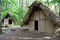
Celtic homestead with storehouse
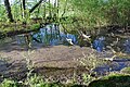
Mardelle
Fire salamander nursery
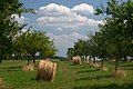
Orchard meadow


Web links
- Information Saar-Hunsrück-Steig dream loop
- Website of the municipality of Rehlingen-Siersburg
- Website of the German Hiking Institute