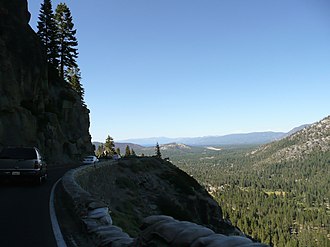
Echo Summit (Pass)
| Echo Summit | |||
|---|---|---|---|
|
View from Echo Summit towards Lake Tahoe |
|||
| Pass height | 2250 m above sea level NN | ||
| region | El Dorado County , California , USA | ||
| Watershed | South Fork American River | Truckee River | |
| Valley locations | Twin bridges | Meyers | |
| expansion | Pass road | ||
| Mountains | Sierra Nevada | ||
| Map (California) | |||
|
|
|||
| Coordinates | 38 ° 48 '47 " N , 120 ° 1' 48" W | ||
The Echo Summit is a mountain pass in the eastern part of El Dorado County in the US state of California . The 2,250 m high pass lies between the valleys of the South Fork American River and Truckee River . It is crossed by US Highway 50 , referred to here as the El Dorado Freeway , which connects the town of Meyers on the eastern side of the valley with the sparsely populated valley of the American River.
history
The pass became passable for the first time in 1913 with the construction of the Lincoln Highway , which ran here as the Sierra Nevada Southern Route (also Pioneer Route ).
From September 6 to 16, 1968, the competitions for the selection of the US athletes participating in the Olympic Games took place at this altitude in order to get used to the altitude of the former venue, Mexico City . One of the first plastic sheets was built for this purpose . Four new world records were set during the competitions.
See also
Individual evidence
- ^ Echo Summit, A Mountain Pass Near The California-nevada Border, Found Its Place In History By Shaping The 1968 Us Olympic Track And Field Team, One Of The Best Ever . In: Chicago Tribune , July 3, 2000. Retrieved October 13, 2011

