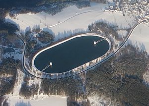
Eggberg basin
| Eggberg basin | |||
|---|---|---|---|
| Aerial view of the Eggberg basin | |||
|
|
|||
|
|
|||
| Coordinates | 47 ° 34 '51 " N , 7 ° 57' 35" E | ||
| Data on the structure | |||
| Construction time: | 1963-1966 | ||
| Height above valley floor: | 30 m | ||
| Height above foundation level : | 35 m | ||
| Height of the structure crown: | 701.50 m above sea level NHN | ||
| Building volume: | 700,000 m³ | ||
| Crown length: | 1340 m | ||
| Crown width: | 4.50 m | ||
| Slope slope on the air side : | 1: 2.00 | ||
| Slope slope on the water side : | 1: 1.75 | ||
| Data on the reservoir | |||
| Altitude (at congestion destination ) | 700.00 m above sea level NHN | ||
| Water surface | 12 ha | ||
| Storage space | 2.10 million m³ | ||
| Total storage space : | 2.10 million m³ | ||
| Catchment area | 54.47 km² | ||
The Eggberg basin is the upper basin of the pumped storage power plant in the Säckingen cavern power plant of the Schluchsee plant . The Eggberg basin is located on the Eggberg near Bad Säckingen in the Waldshut district in Baden-Württemberg .
In addition, the basin also has natural tributaries, which are brought in from the rivers Murg , Ibach and Dorfbach via side lines. A 12.5 km long gravity tunnel was created for this purpose.
The basin has a ring dam made of rubble with an asphalt concrete exterior seal.
The Upper Rhine dammed up by a weir serves as the lower basin . At a water level of 289.28 m above sea level. NHN in Rhein, the maximum drop height 410.72 m. At the Rhine weir there is also a run-of-river power plant , the Säckingen Rhine power plant.
literature
- Peter Franke, Wolfgang Frey: Dams in the Federal Republic of Germany . DNK - DVWK 1987, ISBN 3-926520-00-0 .

