Elim (South Africa)
| Elim | ||
|---|---|---|
|
|
||
| Coordinates | 34 ° 36 ′ S , 19 ° 46 ′ E | |
| Basic data | ||
| Country | South Africa | |
| Western cape | ||
| District | Overberg | |
| ISO 3166-2 | ZA toilet | |
| local community | Cape Agulhas | |
| Residents | 1412 (2011) | |
| founding | 1824 | |
|
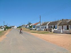
Village street in Elim
|
||
Elim is a former mission station with 1412 inhabitants (as of 2011) in the municipality of Cape Agulhas , Overberg District , Western Cape Province in South Africa . Elim lies between Gansbaai and Bredasdorp .
Elim is named after the Elim oasis from the Old Testament with twelve water springs and 70 palm trees. The founders of the mission station chose the site because of the good water supply.
history
Elim was founded in 1824 by German brothers of the Moravian Church (English: Moravian Church ) under the direction of Hans Peter Hall Beck, in the field of farm Vogelstruiskraal. He began his missionary work with three families from Genadendal . The church bell is over 240 years old and was used in Herrnhut in Germany until 1914 . The village, known for its thatched houses, is now a national monument.
In 1963 the Elim Tehuis was founded. It is a home for 50 children and young people with spastic paralysis and other disabilities. It is supported by the Evangelical Mission in Solidarity (EMS).
Attractions
- Geelkop Nature Reserve
- Watermill from 1833, the largest wooden water wheel in South Africa
- The only memorial stone in South Africa to commemorate the liberation of slaves on the Cape
- Thatched church of the Moravian Brethren
Web links
- Portrait at sahistory.org.za (English)
- Historical information ( Memento from March 25, 2010 in the Internet Archive )
- Information about Elim on the Overberg District website ( Memento of May 27, 2009 in the Internet Archive )
Individual evidence
- ↑ 2011 census , accessed November 18, 2013
- ↑ Between heaven and hell in: FAZ from December 15, 2011, page R3

