Ellewoutsdijk
 flag |
 coat of arms |
| province |
|
| local community |
|
|
Area - land - water |
6.64 km 2 6.5 km 2 0.14 km 2 |
| Residents | 375 (Jan. 1, 2017) |
| Coordinates | 51 ° 25 ' N , 3 ° 53' E |
| Important traffic route |
|
| prefix | 0113 |
| Postcodes | 4436-4438 |
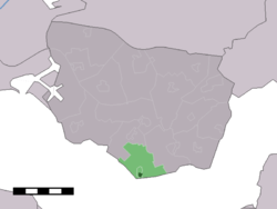
| Location of Ellewoutsdijk in the municipality of Borsele | |
Ellewoudsdijk ( Zeeland Ellesdiek ) is a village in the municipality of Borsele in the Dutch province of Zeeland and is located on the Westerschelde . In 1835 a sea fort was built here together with the fortifications from Terneuzen on the opposite side of the Scheldt . From 1926 to 1934 there was a rail link. The former Ellewoutsdijk station is now a listed building. The church building Kerkje van Ellesdiek was rebuilt in 1950 after the previous building was destroyed in the war in 1944.
The place has a small marina.
Web links
Commons : Ellewoutsdijk - collection of images, videos and audio files
- Ellewoutsdijk: Website of the VVV Zeeland tourist office (German, Dutch, English)
- Fort Ellewoutsdijk Natuurmonumenten (Dutch)
- Fort Ellewoutsdijk VVV Zeeland (Dutch)
Individual evidence
- ↑ Kerncijfers wijken en buurten 2017 Centraal Bureau voor de Statistiek , accessed on April 3, 2018 (Dutch)


