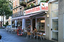
Eppendorfer way

The Eppendorfer Weg in Hamburg is around 3 km long. It runs from southwest to northeast in the districts of Eimsbüttel , 760 m in Hoheluft-West and 730 m in Hoheluft-East and is characterized by a high density of restaurants and small shops. There is still a lot of building stock from the Wilhelminian era, some of which are recognized as cultural monuments. The official street code for Eppendorfer Weg is E197. In the Eimsbüttel area it is crossed by the Ottersbek .
course
The Eppendorfer Weg connects Eimsbüttel with Eppendorf and runs parallel over the entire length between Ring 2 and the Isebek Canal . The entire course of the street is single-lane without a separate cycle path, with a small section shortly before its end being a one-way street. Since the end of 2018, the Eppendorfer Weg has been converted into a Tempo 30 zone in sections.
The Eppendorfer Weg ends in Hoheluft-Ost on the border with Eppendorf, where it turns into Eppendorfer Landstrasse.
history
The section east of the Hoheluftchaussee was laid out from 1896 on the former Wilhelm Gossler country estate and was originally called Gosslerstraße. The St. Mark's Church is also located here . Gosslerstrasse connected Eppendorfer Weg with Adlerstrasse, which in turn led to Lehmweg (at the transition to Eppendorfer Landstrasse). In order to avoid duplicate street names due to the incorporation of the Greater Hamburg Law , all three streets were merged into Eppendorfer Weg in 1950.
Web links
- Yvonne Weiß: Eppendorfer Weg: A tour through the street of temptation. Hamburger Abendblatt , June 20, 2016, accessed on April 12, 2017 .
Individual evidence
Coordinates: 53 ° 35 '0.7 " N , 9 ° 58' 35.8" E