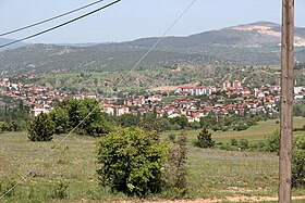
Eskipazar
| Eskipazar | ||||
|
||||
 Eskipazar from the west |
||||
| Basic data | ||||
|---|---|---|---|---|
| Province (il) : | Karabuk | |||
| Coordinates : | 40 ° 57 ' N , 32 ° 32' E | |||
| Height : | 902 m | |||
| Residents : | 6,694 (2018) | |||
| Telephone code : | (+90) 370 | |||
| Postal code : | 78 xxx | |||
| License plate : | 78 | |||
| Structure and administration (as of 2019) | ||||
| Mayor : | Hüseyin Dönmez ( MHP ) | |||
| Website: | ||||
| Eskipazar County | ||||
| Residents : | 13,185 (2018) | |||
| Surface: | 754 km² | |||
| Population density : | 17 inhabitants per km² | |||
| Kaymakam : | Esengül Korkmaz Çiçekli | |||
| Website (Kaymakam): | ||||
Eskipazar ( Turkish for old market ) is a Turkish city and a district in the Karabük Province . The district was founded in 1946 and covers an area of 754 km². The city had 6,694 inhabitants at the end of 2018 and is divided into seven Mahalle (districts). The district includes 50 villages ( Köy ), of which the largest (Hamamli) has 274 inhabitants.
About 5 km southwest of the village of Viranşehir is the ruins of Hadrianopolis .
Attractions
- Excavations of Hadrianopolis
- Asar citadel
- 300 m long ancient rock tunnel from Asar mountain
- Hittite rock tombs
- Akkaya thermal springs
- Ömer Beyler's house
Individual evidence
- ↑ a b nufusune.com , accessed April 15, 2019
Web links
Commons : Eskipazar - collection of images, videos and audio files


