Uaso Nyiro
|
Uaso Nyiro Ewaso Ng'iro or Lagh Dera |
||
|
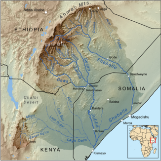
Catchment area of the Juba with the Uaso Nyiro on the left |
||
| Data | ||
| location |
during floods to Somalia |
|
| River system | Juba | |
| Drain over | Juba → Indian Ocean | |
| source | in the Aberdare Range | |
| muzzle | in the Juba shortly before its mouth. Coordinates: 0 ° 0 ′ 36 ″ S , 42 ° 35 ′ 53 ″ E 0 ° 0 ′ 36 ″ S , 42 ° 35 ′ 53 ″ E |
|
| Mouth height |
6 m
|
|
| Catchment area | 15,200 km² | |
|
The Uaso Nyiro in the Shaba National Reserve |
||
The Uaso Nyiro River is a river in Kenya .
geography
The river has its source in the Aberdare Range . From there it flows in a northerly direction. At the place Nyahururu are the 72 meter high Thompson waterfalls , over which it falls. From there it makes a wide bend east over Archer's Post to flow into the Lorian Swamp after Chanler's Falls . After leaving the swamps, it is known as Lagh Dera . It continues to flow in an easterly direction until it finally unites with the Juba . However, it rarely reaches Somalia at all , and only during floods.
National parks
The river is the lifeline of the 165 square kilometer Samburu National Reserve and other national parks in Kenya, including the Shaba National Reserve and the Buffalo Springs National Reserve . Numerous animals live on the river and there are numerous crocodiles in the river.
Individual evidence
- ↑ Frank Grundy: THE 1961 FLOODS IN KENYA page 47 doi : 10.1680 / cocepo1964.44975
- ↑ IWMI Global Wetland Initiative: Kenya ( Memento of the original from July 17, 2010 in the Internet Archive ) Info: The archive link was inserted automatically and has not yet been checked. Please check the original and archive link according to the instructions and then remove this notice. (PDF; 232 kB) page 11
- ↑ CH. LEIBUNDGUT; Institute of Geography, Department of Hydrology, University of Berne, Berne, Switzerland: Runoff regime of a tropical high mountain region (PDF; 788 kB) page 314

