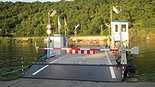
Haßmersheim ferry
The Haßmersheim ferry was a catenary ferry with a chain hoist that operated on the Neckar in Haßmersheim , 115 meters wide and three and a half to four meters deep . It connected the village of Haßmersheim with the station on the Neckar Valley Railway on the other side of the Neckar . The ferry was one of the last overhead line ferries, in Germany only the Straussee ferry in Strausberg, Brandenburg, is operated in this way.
history
A "Hassmersheim ferry" was mentioned in a document as early as 1330 .
A yaw ferry operated at this point until the mid-1930s , which had to be replaced by a chain ferry in the course of the Neckar canalization. First of all, a newly built diesel ferry at the Philipp Ebert & Söhne shipyard in Neckarsteinach was used; the last ferry to operate was built in 1948. The ferry was leased until 1951, after which it was operated by the municipality.
In the 1980s, the ferry was under threat. In 1986 a citizens' initiative was founded to save the ferry. In a referendum on September 18, 1988, 73.04 percent of the voters decided to continue operating the ferry.
The Neckarsteg, a three-meter-wide pedestrian bridge with a span of over 140 meters, has been open to pedestrians since September 17, 2014. The official inauguration took place on October 17th. The ferry service was discontinued on September 24, 2014, the ferry certificate expired on October 17, 2014. For the maintenance of the ferry in general, the city of Heilbronn may be under discussion as the carrier as part of the Federal Garden Show 2019. The ferry was therefore brought to Neckarsteinach for a general overhaul on March 2, 2015 .
technology
The drive of the passenger and car ferry was carried out with the aid of a electric motor of 15 kW power at a voltage of 380 volts. The electrical energy required to operate the ferry was supplied via a four-pole overhead line that is stretched across the Neckar.
The load capacity of the ferry was 15 tons, it was approved for six passenger cars and 60 people. The length was 16.06 meters, the length with superstructures 21.16 m; the width: 6.06 meters, with superstructures 9 m.
Operating times
The ferry operated day and night until 1963, after which operations were limited to the time from 5 a.m. to 9 p.m. (Sundays 8 a.m. to 6 p.m.). In 2013, the ferry operated Monday through Friday from 5:30 a.m. to 8:15 p.m. and on weekends from 9:30 a.m. to 6:15 p.m. The trains only stopped at the Haßmersheim station from around 6 a.m. to 8 p.m. in accordance with the operating times of the ferry and ran through the station without stopping in the morning and evening. At the end of 2013 the station was connected to the Heilbronn Nord light rail . The construction of the Neckarsteg, which has been replacing the ferry since September 2014, was directly related to this project. During floods, a ferry boat (from 2003 "Patriot", previously "Dieter"), which is still used today for excursions, operated from time to time.
Individual evidence
- ↑ a b c d page about the ferry on the Haßmersheim website
- ↑ a b c d e Sections of our home community Haßmersheim in the course of contemporary history ( Memento of the original from February 23, 2014 in the Internet Archive ) Info: The archive link was inserted automatically and has not yet been checked. Please check the original and archive link according to the instructions and then remove this notice. (PDF; 2.7 MB) on the municipality's website, accessed on February 6, 2014
- ^ Haßmersheim ferry: Now it's gone - Mosbach - Rhein Neckar newspaper
- ↑ Heiko Schattauer: From June 2014 you can walk across the Neckar. Rhein-Neckar-Zeitung, January 10, 2013, accessed on July 7, 2015 .
- ↑ Call for tenders for the new construction of the Neckar stop and footbridge, accessed on May 26, 2013.
- ↑ Christian Beck: Haßmersheimer ferry replacement "Patriot" is now a pleasure boat. Rhein-Neckar-Zeitung, April 9, 2015, accessed on July 7, 2015 .
Coordinates: 49 ° 18 ′ 6.8 ″ N , 9 ° 9 ′ 10.4 ″ E


