Forch
| Forch | |||
|---|---|---|---|
|
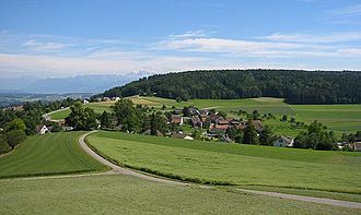
View from the Forchdenkmal to the Küsnacht side and the Pfannenstiel |
|||
| Pass height | 679 m above sea level M. | ||
| Canton | Zurich | ||
| expansion | Pass road | ||
| particularities | Forchbahn | ||
| map | |||
|
|
|||
| Coordinates | 691 781 / 242280 | ||
The Forch is a village and a transition over the between Lake Zurich and Greifensee nearby ridge Pfannenstiel in the Canton of Zurich in Switzerland . The pass is at 679 m above sea level. M. between the Wassberg in the north and the actual pan handle in the south.
Forch was originally a hamlet on the road at the pass crossing, which had an inn and eight other houses - including a horse changing station. Today, forch - for example by post - usually includes the entire cohesive settlement around the pass:
- The merged districts of Aesch and Scheuren in the eastern municipality of Maur , where over 3,100 residents lived at the end of 2018.
- The hamlets of Kaltenstein , Neue Forch and Wangen , which belong to the municipality of Küsnacht to the west .
- The Guldenen forest clearing on the Pfannenstiel in the south of the Forch Pass is also included in the Forch. The houses in Hinter Guldenen belong to the municipality of Maur, Vorder Guldenen to the municipality of Egg .
With the Forchbahn and the Forch expressway A 52, Forch has good transport connections to Zurich, about ten kilometers away . Accordingly, many residents commute to the city. Nevertheless, the area was able to retain its rural character. The infrastructure has remained modest with kindergartens, primary schools, old people's homes as well as small businesses and restaurants.
Popular excursion destinations for walkers are the two hills Wassberg ( 748 m above sea level at Chapf ) in the north and Pfannenstiel ( 851 m above sea level ) in the south. The Forchdenkmal , officially known as the Wehrmännerkmal , stands on the ascent to the Wassberg .
The Forch is the venue for some sporting events such as the Forchlauf (21.5 kilometers from Zurich- Fluntern ) and was often on the course of the Zurich cycling championship .
Forch is also attracted to parapsychologists who claim that a tree in Aesch has measured more than 750,000 Bovis units - allegedly the highest value in Switzerland. The effect of this measurement method is disputed by natural scientists . The tree was felled in 1999 by storm Lothar .
The locals always use the place name with an article. It is derived from the Latin furca , which stands for the pass crossing or a fork in the road.
Web links
- Martin Illi: Forch. In: Historical Lexicon of Switzerland .
- Aesch. Maur community
- Aesch / Forch. Magic places
Individual evidence
- ^ A b Charles Knapp, Maurice Borel, Victor Attinger, Heinrich Brunner, Société neuchâteloise de geographie (editor): Geographical Lexicon of Switzerland . Volume 2: Emmenholz - Kraialppass . Verlag Gebrüder Attinger, Neuenburg 1904, p. 138, keyword Forch ( scan of the lexicon page ).
- ^ Dufour map, approx. 1865
- ^ Maur in numbers. In: Municipality of Maur. Retrieved August 7, 2019 .
- ^ Gisela Goehrke: Private road instead of access to the swimming pool . In: Maurmer Post . No. 17 . Ebmatingen April 24, 2009, p. 2–3 ( PDF ( Memento of December 18, 2015 in the Internet Archive ) [accessed on December 1, 2015]).
- ↑ Nicole Roos: Where you feel good and recharge your batteries . In: Tages-Anzeiger . Zurich August 18, 2010 ( Tagi-Online ).
- ^ Felix Aeppli: History of the community Maur . Ed .: Local councilor Maur. Municipality of Maur, Maur 1979, p. 32 .


