Fallon (Nevada)
| Fallon | |
|---|---|
 Naval Air Station Fallon |
|
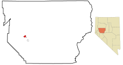
| Fallon in Churchill County | |
| Basic data | |
| State : | United States |
| State : | Nevada |
| County : | Churchill County |
| Coordinates : | 39 ° 28 ′ N , 118 ° 47 ′ W |
| Time zone : | Pacific ( UTC − 8 / −7 ) |
| Residents : | 7,536 (as of: 2000) |
| Population density : | 953.9 inhabitants per km 2 |
| Area : | 7.9 km 2 (approx. 3 mi 2 ) of which 7.9 km 2 (approx. 3 mi 2 ) is land |
| Height : | 1207 m |
| Postcodes : | 89406, 89407, 89496 |
| Area code : | +1 775 |
| FIPS : | 32-24100 |
| GNIS ID : | 0840412 |
| Website : | www.cityoffallon.com |
| Mayor : | Ken Tedford Jr. |
Fallon is a small town in western Nevada with a population of about 7,500. It is located in Churchill County and is its administrative seat . The area is very dry as Fallon is in the Stillwater Range . The name comes from the larger neighboring town of Stillwater . To the southwest of Fallon are small lakes and to the west the city of Reno . Naval Air Station Fallon , one of Fallon's most important employers, is located in the city .
geography
US Highway 50 forms the main road through the city. It is one of the towns on what is often referred to as the Loneliest Road in America . The city of Austin is 180 km away. Fallon's geographic coordinates are 39 ° 28 ' N , 118 ° 47' W (39.472792, −118.778826).
According to the United States Census Bureau , the place has an area of 7.9 km² , of which 7.9 km² is land and 0.1 km² (= 0.65%) is water.
Fallon is primarily an agricultural community. Although the city is located in an arid area, around 200 km² of farmland are irrigated and used for agriculture. Mainly alfalfa is grown.
About eleven kilometers east of Fallon is near the highway Grimes Point, a site with up to eight thousand year old rock paintings, which were created by the residents on the shores of the former Lake Lahontan .
Demographics
At the time of the United States Census 2000, Fallon had 7536 people. The population density was 954.0 people per km ². There were 3336 housing units at an average of 422.3 per km ². The Fallon population was 81.32% White , 2.04% Black or African American , 3.40% Native American , 5.00% Asian , 0.37% Pacific Islander , 3.4% said other races belong to and 4.47% named two or more races. 9.89% of the population declared to be Hispanic or Latinos of any race.
The residents of Fallon were distributed to 3,004 households out of which 35.4% had children under the age of 18. 42.7% of households were married, 15.3% had a female head of the household without a husband and 37.5% were not families. 30.7% of households were made up of individuals and someone lived in 11.4% of all households aged 65 years or older. The average household size was 2.45 and the average family size was 3.06.
The population was divided into 28.4% minors, 10.3% 18–24 year olds, 29.7% 25–44 year olds, 19.4% 45–64 year olds and 12.2% aged 65 and over or more. The median age was 32 years. For every 100 women there were 95.7 men. For every 100 women over 18, there were 91.5 men.
The median household income in Fallon was 35,935 US dollars and the median family income reached the amount of 41,433 US dollars. The median income for men was $ 35,356 compared to $ 22,818 for women. The per capita income was $ 16,919. 12.6% of the population and 9.5% of families had an income below the poverty line , of which 15.6% of minors and 10.3% of those aged 65 and over were affected.
Twin cities
- Wani , Georgia
sons and daughters of the town
- Martin Heinrich (* 1971), politician
- Michelle Krusiec (born 1974), actress
Individual evidence
- ↑ Grimes Point Petroglyph Trail ( English ) Nevada Bureau of Land Management . Archived from the original on December 10, 2006. Info: The archive link was automatically inserted and not yet checked. Please check the original and archive link according to the instructions and then remove this notice. Retrieved June 27, 2009.
Web links
- Grimes Point with illustrations of the rock art
- Chamber of Commerce
