Faro
| Faro | ||
|---|---|---|
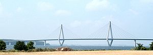
| The south bridge from Farø to Falster | ||
| Waters | Baltic Sea | |
| Archipelago | Storstrømmen | |
| Geographical location | 54 ° 57 '0 " N , 11 ° 59' 30" E | |
|
|
||
| surface | 93 ha | |
| Residents | 4th (January 1, 2020) 4.3 inhabitants / km² |
|
| The north bridge from Farø to Sjælland | ||
Farø is a Danish island in Storstrømmen between Sjælland and Falster . The strait between Farø and Sjælland is called Kalvestrøm . Two bridges, the so-called Farø bridges , connect Farø with Falster and Sjælland and thus lead the combined European roads E 47 and E 55 from Falster to Sjælland. There is a rest stop at the exit of the same name on the island. In addition, a dam connects the island with the neighboring island of Bogø . Farø is 93 hectares and has 4 inhabitants (January 1st, 2020).
Farø is in the parish of Bogø ( Bogø Sogn ), which belonged to Harde Mønbo Herred in what was then Præstø Amt until 1970 , and then to Møn Kommune in what was then Storstrøms Amt . Since the municipal reform on January 1, 2007 , Farø has belonged to Vordingborg Municipality in the Sjælland region .


