Pheasant Island (Basque Country)
| Pheasant Island | ||
|---|---|---|
| The Pheasant Island (in the center of the picture - the buildings in the background are on the Spanish mainland) | ||
| Waters | Bidasoa | |
| Geographical location | 43 ° 20 '34 " N , 1 ° 45' 55.8" W | |
|
|
||
| length | 224 m | |
| width | 41 m | |
| surface | 0.682 ha | |
| Highest elevation | unnamed 6 m |
|
| Residents | uninhabited | |
The Pheasant Island ( Spanish : Isla de los Faisanes ; French : Île des Faisans , Île de l'Hôpital , or Île de la Conférence ; Basque : Faisaien uhartea or Konpantzia ) is an uninhabited inland island on the Spanish-French border river Bidasoa 5.9 km ( 4.2 km as the crow flies ) southeast of its confluence with the Atlantic .
The island is 224 meters long and up to 41 meters wide. With an area of 6,820 m², it is the smallest condominium in the world and is administered every six months alternately by Spain (February 1 to July 31) and France (August 1 to January 31). The city of Hendaye takes on this task for the French side, and the city of Irún for Spain . The island used to belong to the municipality of Hondarribia , Gipuzkoa .
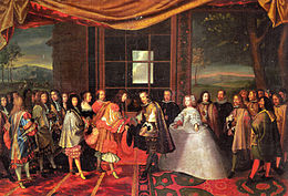
Due to its location in the border area, the island was often the scene of historical events. Hostages were exchanged here, marriageable infants were handed over and in 1660 the Peace of Pyrenees was signed by Louis XIV and Philip IV of Spain after long negotiations (1659). In the middle of the island, a stele commemorates the signing of the Peace of the Pyrenees.
Web links
- Information about the Pheasant Island on the website of the municipality of Irún ( Memento from January 6, 2007 in the Internet Archive )
- The island that switches countries every six months. In: BBC.co.uk , January 28, 2018 (English)


