Irun
| Irun parish | ||
|---|---|---|
| coat of arms | Map of Spain | |

|
|
|
| Basic data | ||
| Autonomous Community : |
|
|
| Province : | Gipuzkoa | |
| Comarca : | Bajo Bidasoa | |
| Coordinates | 43 ° 20 ′ N , 1 ° 48 ′ W | |
| Height : | 20 msnm | |
| Area : | 42.40 km² | |
| Residents : | 62,401 (Jan. 1, 2019) | |
| Population density : | 1,471.72 inhabitants / km² | |
| Postal code : | 20300-20305 | |
| Municipality number ( INE ): | 20045 | |
| administration | ||
| Mayor : | José Antonio Santano Clavero (PSE-EE) | |
| Website : | www.irun.org | |
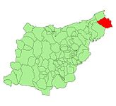
| Location of the municipality | ||

|
||
Irun ( Spanish Irún ) is a Spanish city in the province of Gipuzkoa in the Basque Country Autonomous Region . 62,401 inhabitants (as of January 1, 2019) live in Irun on an area of 42 km².
location
Irun is located 15 km east of the provincial capital San Sebastián, right on the Spanish-French border. In the east of the city flows the border river Bidasoa , which flows into the Bay of Biscay near the neighboring city of Hondarribia, three kilometers away . The French town of Hendaye is on the opposite side of the Bidasoa .
history
The early history of Irun is unknown, but there are remains of Roman settlement. A branch of the pilgrimage to Santiago de Compostela ( Way of St. James ) led through Irun and ensured constant growth. The border location with France often caused armed conflicts and sieges. Irun was first mentioned in 1203 when Alfonso VIII of Castile granted the city of Hondarribia the privilege of jurisdiction in the Carta Puebla .
On the Pheasant Island in the border river Bidasoa , the marriage contract was signed in 1659 between Louis XIV. And the Spanish King of the Pyrenees and a little later between Louis XIV. And Maria Teresa of Spain (always called Marie-Thérèse d'Autriche in France). The island is managed by the French city of Hendaye and Irun every six months.
It was not until February 17, 1766, that Irun received full independence from Hondarribia, which until then had been responsible for civil and criminal justice. In 1814 Irun was assigned to the province of Guipúzcoa. On August 15, 1913, Irun was made a city. During the Spanish Civil War 1936-1939, the city was largely destroyed during the nationalist offensive of Guipúzcoa .
population
| year | 1800 | 1900 | 1910 | 1920 | 1930 | 1940 | 1950 | 1960 | 1970 | 1981 | 1991 | 2000 | 2008 |
|---|---|---|---|---|---|---|---|---|---|---|---|---|---|
| Residents | 1,180 | 9,912 | 12,120 | 14,161 | 17,670 | 14,368 | 19,956 | 29,814 | 45,060 | 53,445 | 53,276 | 56,486 | 61,419 |
traffic
Irun is served by both the French state railway SNCF ( LGV Sud Europe Atlantique with TGV ) and the Spanish RENFE . The connection to the north is the Bordeaux – Irun line and the Madrid – Hendaye line to the south .
Attractions
- Santa María del Juncal Church (16th century)
- Pilgrimage museum of the Ama Xantalen chapel
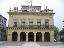
- Baroque town hall with the San Juan column (1564) on the forecourt, which was dedicated to the resistance against French invaders and symbolizes the independence of the residents of Irun
sons and daughters of the town
- Luis Regueiro (1908-1995), football player
- Santiago Urtizberea (1909–1985), football player
- Javier Irureta (* 1948), football player and coach
- Fermin Muguruza (* 1963), musician
- Juan Manuel Gárate (* 1976), cyclist
- Iñaki Descarga (* 1976), football player
- Amaia Montero (* 1976), singer
- Gorka Fraile (* 1978), tennis player
- Julen Aguinagalde (* 1982), handball player
- Oier Olazábal (* 1989), football goalkeeper
Web links
Individual evidence
- ↑ Cifras oficiales de población resultantes de la revisión del Padrón municipal a 1 de enero . Population statistics from the Instituto Nacional de Estadística (population update).
← Previous location: - | Irun | Next town: Hernani (Spain) →


