Ferndale (Wales)
|
Ferndale Welsh Glynrhedynog |
||
|---|---|---|
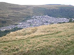
| View of Ferndale from the mountain above Blaen-llechau | ||
| Coordinates | 51 ° 40 ′ N , 3 ° 27 ′ W | |
|
|
||
| Residents | 4419 | |
| administration | ||
| Part of the country | Wales | |
| Preserved County | Mid glam organ | |
| Unitary authority | Rhondda Cynon plate | |
Ferndale ( Welsh Glynrhedynog ) is a small town in the Rhondda Valley in the County Borough of Rhondda Cynon Taf in Wales .
The former mining town lies in the upper valley of the Rhondda Fach on a ledge on the mountainside above the right, western bank of the river. The 300 m high town is the highest town in Rhondda Cynon Taf . Due to its location in the upper valley and the rocky, wooded surroundings, it is isolated in contrast to many other settlements in the Rhondda Valley.
history
In 1847 there were only two small farms on the site of the town, surrounded by meadows and forests. The name Ferndale is a translation of the Welsh name Glyn Rhedynog , which means valley covered with ferns , and was first used in the 1860s by entrepreneur David Davis when he was digging a shaft for a coal mine. While the first 40 miners of the mine still lived in the same house, as almost everywhere in the Rhondda Valley, the housing situation became a problem with the influx of additional workers. In 1867, the majority of the then 800 inhabitants lived in simple wooden huts. Only after the arrival of more workers did the mining company start building simple, stone terraced houses. In 1867 and 1869 there were two major mining accidents in the Ferndale Colliery , in which 178 and 53 miners respectively died.
Ferndale quickly became the largest settlement in Rhondda Fach, with a business center emerging on The Strand . In 1891 a hospital was built. Several non-conformist churches and chapels have been built in the city , including Trerhondda Chapel in 1867 and Wesleyan Methodist Chapel in 1880 , which was rebuilt after a fire in 1893. Darran Park and an open-air swimming pool were created for local recreation, and a public library and a training center for the labor movement were also built.
The mine began to decline after the First World War and was closed in 1959.
traffic
Ferndale is connected by the A4233 with Porth in the south and Aberdare in the Cynon Valley , while another road leads via Penrhys to Treorchy and Tonypandy into the valley of the Rhondda Fawr to the west.
sons and daughters of the town
- Stanley Baker (1928–1976), actor
- Brian Bedford (born 1933), football player
- Stuart Richardson (* 1973), rock musician
- Meirion James Trow (* 1949), writer
Web links
- Rhondda Cynon Taf: Towns and Villages - Fernsdale
- Rhondda Cynon Taf Library Service “Our Past”: Ferndale
- Glamorgan-Gwent Archaeological Trust: Historic Landscape Characterization
Individual evidence
- ^ Office for National Statistics: Ferndale. Retrieved September 10, 2015 .

