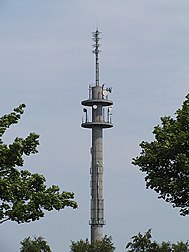
Telecommunication tower Otterndorf
|
Telecommunication tower Otterndorf
|
||
|---|---|---|
| Basic data | ||
| Place: | Otterndorf | |
| Country: | Lower Saxony | |
| Country: | Germany | |
| Altitude : | 3 m above sea level NHN | |
| Coordinates: 53 ° 48 ′ 32.5 ″ N , 8 ° 53 ′ 1.5 ″ E | ||
| Use: | Telecommunications tower , broadcasting station | |
| Accessibility: | Transmission tower not open to the public | |
| Owner : | German radio tower | |
| Tower data | ||
|
Construction data:
|
||
| Total height : | 90 m | |
| Data on the transmission system | ||
| Waveband : | FM transmitter | |
| Radio : | VHF broadcasting | |
| Position map | ||
|
|
||
The Otterndorf telecommunications tower is located on the western outskirts of the city of Otterndorf , ten kilometers east of Cuxhaven . The 90 meter high telecommunications tower of the Deutsche Funkturm is a type tower of the type FMT 10.
In addition to the non-public radio relay, the region around Cuxhaven is supplied with radio programs from here. The private broadcasters from Hamburg also use this broadcasting location to supply the Neuwerk island belonging to the state of Hamburg .
Frequencies and Programs
Analog radio (VHF)
|
Frequency (MHz) |
program | RDS PS | RDS PI | Regionalization |
ERP (kW) |
Antenna pattern round (ND) / directional (D) |
Polarization horizontal (H) / vertical (V) |
|---|---|---|---|---|---|---|---|
| 88.5 | Radio Hamburg | RADIO_HH | D358 | - | 2 | D (280-320 °) | H |
| 93.6 | Rock antenna Hamburg | _ROCK HH__ | D359 | - | 2.7 | D (270-330 °) | H |
| 101.6 | Deutschlandfunk | __DLF___ | D210 | - | 2 | D (90–240 °) | H |
| 102.6 | ffn |
ffn_Cux_ __ffn___ |
DB88 (regional), D388 |
Cuxhaven | 20th | D (80–240 °) | H |
| 104.6 | Aerial Lower Saxony |
Ant._OFR antenna_ |
D889 (regional), D389 |
East Frisia / coast | 20th | D (80–240 °) | H |
| 107.7 | Deutschlandradio Kultur | DKULTUR_ | D220 | - | 20th | D (80–240 °) | H |


