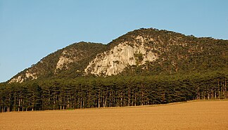
Fischau foothills
| Fischau foothills | ||
|---|---|---|
|
View of the Fischau foothills from Zweiersdorf over the New World depression , on the right the Kienberg (650 m), then Mitterberg (520 m), Prosset Gorge, Emmerberg Castle with Schlossberg (584 m), Großenberg (605 m), Muthmannsdorf |
||
| Highest peak | Kienberg ( 650 m above sea level ) | |
| location | Lower Austria | |
| part of | Gutenstein Alps , mountain range 1864 according to Trimmel , | |
|
|
||
| Coordinates | 47 ° 49 '0 " N , 16 ° 5' 50" E | |
|
Schlossberg ( 584 m ) from the west |
||

The Fischau foothills are a promontory of the Hohe Wand , the highest point is the Kienberg with a height of 650 m above sea level. A. They belong to the Wiener Neustädter Bergkranz.
expansion
The Fischau foothills begin in the north at Markt Piesting and extend west from Bad Fischau-Brunn to Winzendorf , where they are cut by the Prossetbach . Then they run north past Dörfles to Willendorf . To the northwest of the Fischau foothills, the vast New World depression extends right up to the foot of the Hohe Wand. The Warme Fischa rises on the southeast side of the Fischau foothills .
geology
The Fischau Mountains, also known as the “Emmerbergzug”, strike as a high relief zone at an altitude of 500 to 600 m in a north-easterly direction and are bounded on the one hand by the Gosau Basin of the New World and on the other by the early-tertiary sediments of the Vienna Basin. The only surface drainage in the New World takes place across the Fischau Mountains in the form of the Prosset Gorge , an epigenetic denudation breakthrough . The Kienberg is set off from the main mass of the Hallstätter limestone area of the Hohen-Wand ceiling in the southwest, the higher parts of which are built up from Wetterstein limestone from the Schneeberg ceiling. Likewise, the north-east part with the Mahlleiten ( Malleiten ) and the Steinereben are made of Wetterstein limestone . Here the Cretaceous sedimentary rocks of the New World interlock with the Triassic rocks and, together with the bauxite deposits on the Auriegel , enable the interpretation of different generations of reliefs and forms of the paleocarst . Tertiary the rocks of the edge region are also of the Vienna basin, of which in particular the important Leithakalk are and the pannonen Piesting conglomerates ( "hard gravel") to lead, which are also used for the formation of a cavity in question.
caves
There are a total of 67 caves in the cadastral area of 1864 - Fischauer Vorberge , the largest being the Eisenstein cave , which is a show cave (cave cadastre number 1864/1); Also of interest are the Große Kollerhöhle (1864/14, natural monument) and the labyrinthine and tiered Emmerberghöhle (1864/3) (both barred). Furthermore, the Hofmannshöhle (1864/8), Zigeunerhöhle (1864/21), Großes Zwerglloch (1864/22), Falschmünzerhöhle (1864/4), Promenadensteighöhle (1864/29) and the Steinere Stadl (1864/18) from Importance because they represent important prehistoric sites.
Neighboring communities
Neighboring communities are Markt Piesting , Wöllersdorf-Steinabrückl , the health resort Bad Fischau-Brunn , Winzendorf-Muthmannsdorf , the community of Hohe Wand and Willendorf .
vegetation
Mainly pines grow on the Fischau foothills .
Web links
- Benno Plöchinger; with contributions by F. Brix, A. Kieslinger and Hubert Trimmel : Explanations of the geological map of the Hohe Wand area (Lower Austria). (PDF; 7.4 MB) Federal Geological Institute , Vienna, 1967, accessed on September 20, 2010 .


