
Hohe Wand (Gutenstein Alps)
| High wall | ||
|---|---|---|
 The western part of the Hohe Wand with steep rock faces sloping south, in the center of the picture the high fall wall |
||
| height | 1132 m above sea level A. | |
| location | Lower Austria , Austria | |
| Mountains | Mountain range 1863 to Trimmel , Gutenstein Alps | |
| Dominance | 4.7 km → Drought Wall | |
| Notch height | 392 m ↓ ashtray | |
| Coordinates | 47 ° 50 '2 " N , 16 ° 2' 53" E | |
|
||
| rock | Lime, dolomite | |
| Age of the rock | 220 Ma (Upper Triassic) | |
 Overview map (restaurants) of the Hohe Wand Nature Park |
||

The Hohe Wand in southern Lower Austria is a pronounced karst plateau 8 km long and 2.5 km wide, at an altitude of 900 to 1000 m and culminating in the Plackles ( 1132 m ).
General
The name is derived from the steep rock faces on the south and south-east side. The high plateau extends from the Plackles area in the southwest to the so-called Wandeck in the northeast.
The Hohe Wand plateau can be reached via a toll road built in eleven months and opened on December 3, 1932 by Karl Buresch (1878–1936), Governor of Lower Austria, which branches off the traffic route between Stollhof and Maiersdorf . From August 14, 1965 until the dismantling on August 10, 1994, the first Lower Austrian double chairlift existed from Grünbach to the Plackles summit, which took passengers to the Hohe Wand in 19 minutes. Easy but rarely used hiking trails lead from the Dürnbachtal , from Grünbach and from the “back”, from Miesenbach , up the mountain. Most of the climbs on the south and south-east side are more demanding, you need surefootedness and a good head for heights. Most of the more than 700 climbing routes of all levels of difficulty can be found in this area ; There are also numerous via ferratas , but also easy paths (e.g. Brünnlries).
There are numerous caves in the area of the Hohe Wand; the unicorn cave in the Hirnflitzstein near Dreistetten is open to the public as a show cave . According to the State Association for Speleology in Vienna and Lower Austria, there are around 250 caves in the Hohe Wand area. For climbers, the descent into the wind hole ( cadastral number 1863/30), a shaft cave in the Saugraben right next to the marked path, is also important.
Because of its peripheral location on the Vienna Basin and its accessibility by car, the Hohe Wand is also popular starting points for paragliders and hang-gliders . There are three launch sites for paragliders and hang-gliders: the most frequented eastern launch site, the demanding southern launch site, which is mainly used by hang-gliders, and the little-used launch site at Almfrieden. The Hohe Wand is particularly suitable for flying in south-east winds and is a local mountain of the Viennese.
Numerous mountain inns and shelters can be found on the plateau, but also many weekend houses , especially in the so-called Wanddörfl.
Part of the Hohe Wand is protected as the Hohe Wand Nature Park . Under the title “Hohe Wand Nature Park”, however, tourist attractions are also marketed, some of which are criticized as difficult to reconcile with a nature park, in particular the “Skywalk”. This 18-ton viewing platform , which protrudes around five meters above the rock face , was built in 2002 by the Hohe Wand Nature Park Association.
In 2004, not far from the former Wiener Neustädter Haus (today: Alpine and Local History Museum Hohe Wand ), an 18-meter-high steel observation tower was built, offering a view of the Piestingtal, Schneeberg and Ötscher .
After three alpine ibex escaped from an enclosure in 2003 , these animals reproduced relatively strongly on the Hohe Wand, although the real habitat of the animals is high alpine area. In 2009 there were around 40 animals and in 2011 around 60 animals were estimated. Because of this high increase and the resulting heavy browsing on plants and forest, nine specimens were released for shooting in 2011, twelve in 2012 and thirty in 2013. Despite these kills, the colony grew to around 75 animals in 2013. The hunters therefore demanded a higher shooting rate in 2013/14 and it was considered to relocate some of the animals to a high alpine area of the federal forests in Altenmarkt im Pongau .


The Skywalk built in 2002 above the "Sundial"
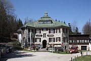
Nature Park Parlor as well as the Hohe Wand Alpine and Local History Museum (previously: Wiener Neustädter Haus)
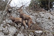
Alpine ibex next to the Völlerinsteig when mating


.JPG)
geology
The predominantly forested plateau has inactive karst valleys (e.g. ladder trenches, suction trenches) as well as sinkholes and karst hollows (e.g. long meadow with the “Am Lurf” shrinkage). The plateau is built up from the Noric Hallstatt limestone (= "wall limestone ") of the high alpine Hohe Wand ceiling, only in the south-west are the main dolomite and other rocks involved. The Hallstätter Kalk dips towards the southeast with a mighty flexure to the Gosau Basin of the New World and forms the SW-NE running, eponymous wall precipices from around 200 m high with numerous small and medium caves here in an impressive cohesion. The north-west slope of the Hohe Wand is criss-crossed by two rock gorges, the Großer and the Kleiner Klause, which are also characterized by the presence of smaller karst caves.
Easy ascent routes
.JPG)
The following paths and trails are sorted from the southwest of the Hohe Wand (the southern beginning of the wall formations) via the mainly east-facing walls, the north and northwest back to the southwest (i.e. counterclockwise).
- Pfarrersteig
- Grafenbergweg
- Ladder trench
- Tramway
- Krumme Ries (from Maiersdorf)
- Ladder path
- Drobilsteig
- Unicorn Cave Trail
- Waldeggersteig (Great Hermitage)
- Krumme Ries (Small Klause)
- More easy ascent routes
- Bründlries:
- A blue-marked ascent and descent path in the southeast of the Hohe Wand and east of the Hanselsteige. The old, narrow, steep forest path was allegedly used for timber transport in the past. The start of the trail on the valley side is near the Loderhof ( 47 ° 50 ' N , 16 ° 5' E ) and the upper one in the area of the forest nature trail.
- Springlessteig (very easy via ferrata) :
- An ascent and descent path in the southwest of the Hohe Wand, which was built in 1899 by the Austrian Tourist Club (ÖTK) and is marked in red, white and red. At a steep trail rope secured with passages and a short ladder at the base of the wall with the difficulty level A . The approach is from Oberhöflein or Zweiersdorf . The actual climb begins at the foot of the wall ( 47 ° 49 ′ N , 16 ° 1 ′ E ) and ends at the meadow below the Hubertushaus. ( 47 ° 49 ′ N , 16 ° 2 ′ E )
- Völlerinsteig:
- The green marked ascent path in the central southern area of the Hohe Wand was built in 1897 by the Austrian Tourist Club (ÖTK) and is also the approach for the via ferrata Frauenlucke and Blutspur as well as the ÖTK climbing garden. The entrance is at the Wandfußsteig ( 47 ° 50 ′ N , 16 ° 3 ′ E ) and the exit near the Alpengasthof Postl ( 47 ° 50 ′ N , 16 ° 3 ′ E ) . Access is usually from the sundial parking lot, which is located next to the first bend on the toll road ( 47 ° 50 ' N , 16 ° 3' E ) .

- Wagnersteig (very easy via ferrata) :
- The establishment marked yellow and descent path in the southwest of the High wall connects the foot of the High wall with the Great pulpit and has a difficulty level A . The path, named after Johann Wagner and provided with many wire ropes and iron ladders, was built by the ÖTK , Wiener Neustadt section and opened on June 30, 1930; In 2001 the ÖTK carried out a general renovation. As a rule, access is from the parking lot at Seiser Toni . Then you climb eastwards to the footpath marked in blue. Follow this in an easterly direction until you come to the Wagnersteig marked yellow. ( 47 ° 49 ' N , 16 ° 1' E ) The exit is next to the Große Kanzel or the Wilhelm-Eichert-Hütte ( 47 ° 49 ' N , 16 ° 1' E ) .
- Zischkasteig:
- An ascent in the eastern area of the Hohe Wand, which is marked green. The upper entry and exit is located immediately to the east of the Herrgottschnitzer house. ( 47 ° 51 ' N , 16 ° 5' O ) The valley-side riser beginning is located on the connection path between Dreistetten Stollhof and in the region of CHF court. ( 47 ° 51 ′ N , 16 ° 5 ′ E )
Via ferratas


- Blood trail:
- A short (approx. 30 meters in altitude) but extremely difficult via ferrata in the upper area of the Hohe Wand between the HTL-Steig and the Völlerinsteig or ÖTK climbing garden with difficulty level E and a short uninsured 3+ point at the entrance. ( 47 ° 50 ′ N , 16 ° 3 ′ E ) The access to the via ferrata, built in 1994, is via the HTL-Steig or the Völlerinsteig / ÖTK climbing garden. The exit is about 15 meters west of the exit from the HTL-Steige. ( 47 ° 50 ′ N , 16 ° 3 ′ E )
- Frauenluckensteig:
- A short, blue-marked trail with around 30 meters in altitude and a difficulty level of B in the central part of the Hohe Wand. The entrance is a left branch in the upper area of the Völlerinsteige ( 47 ° 50 ' N , 16 ° 3' E ) and the exit is near the Alpengasthof Postl. ( 47 ° 50 ' N , 16 ° 3' O ) names refer to around 12 meters high shaft cave woman Lucke (register number 1863/8), which is ascended by means of a ladder.
- Ganghofersteig:
- A short via ferrata in the east of the Hohe Wand with around 60 meters in altitude and a level of difficulty B / C. The ascent to the via ferrata, built in 1928, takes place over the Zischkasteig and the exit is located immediately east of the Herrgottschnitzerhaus. ( 47 ° 51 ′ N , 16 ° 5 ′ E )
- Mountain Club Trail:
- The via ferrata in the southwest of the Hohe Wand, which leads over the Weningerwand to the high plateau, has a difficulty level D. It is one of the longest via ferrata on the Hohe Wand with around 200 meters in altitude and the first in eastern Lower Austria with a rope bridge. The via ferrata was built by the Austrian Mountain Association on the occasion of 150 years of the Austrian Alpine Association (2012), although the opening did not take place until May 1, 2013 due to certain delays. As a rule, access is via Seiser-Toni ( Grünbach am Schneeberg ). The entrance is a little above the wall footpath at the approach to the Turmsteig / Wildenauersteig. ( 47 ° 49 ' N , 16 ° 1' E ) The exit is between the Hubertushaus and the Wilhelm-Eichert-Hütte.
- Hanselsteig:
- An easy via ferrata with around 100 vertical meters and difficulty level B in the southeast of the Hohe Wand. The path was laid out in 1911 by master plumber Johann Hansel. A kind of rest area has been set up beneath a rock overhang, the so-called "Karnitschstüberl", where the Steigbuch is also stored. The ascent ( 47 ° 50 ′ N , 16 ° 4 ′ E ) is via Loderhof, a district of Stollhof in the northeast and the exit is between the Kohlröserlhaus and the Herrgottschnitzerhaus. ( 47 ° 51 ′ N , 16 ° 4 ′ E )
- Kammerlingsteig:
- An exposed steep slope crossing between Holzknechtsteig and Turmsteig.
- Nature friend trail:
- The Naturfreundesteig is a north-facing ascent over the Kleine Klause to the Hohe Wand plateau. The actual via ferrata, built in 1924 by the tourist association “Die Naturfreunde”, has a height difference of around 100 meters and a level of difficulty A / B, although it can be bypassed via the “Krumme Ries” or the “Jägerweg”. The ascent is via Dürnbach and the exit is between the Waldeggerhaus and the Naturparkstüberl.
- ÖTK-Steig (until 2016: HTL-Steig):
- An extreme via ferrata with difficulty level D / E and an altitude difference of around 210 meters. The entrance is at the foot of the wall and around 100 meters above the sundial parking lot next to the toll road between Stollhof and Maiersdorf ( 47 ° 50 ' N , 16 ° 3' E ) . The exit is to the left of the Skywalk next to the Alpengasthof Postl. ( 47 ° 50 ′ N , 16 ° 3 ′ E ) The via ferrata was built in 1999 on the occasion of the 125th anniversary of the HTL Wiener Neustadt . The via ferrata has been closed for a long time several times, for example in 2010 after a fatal fall. In autumn 2016, after several falls, there was another suspension. During the subsequent general renovation by the ÖTK, the trail was slightly disarmed and renamed the ÖTK-Steig when it reopened in April 2018.
- Steirerspur:
- This practice via ferrata next to the Hubertushaus has a difference in altitude of around 20 meters and a difficulty level of C. The via ferrata was built in 2004 by the Austrian Mountain Association of three Styrian mountain guides. The entrance is around 100 meters east of the Hubertushaus.
- Währingersteig:
- A short via ferrata with around 60 meters in altitude and difficulty level C. The via ferrata in the east of the Hohe Wand immediately east of the Einhornhöhle leads over the vertical Hirnflitzstein east face and was originally called Toni-Baltzarek-Steig. In 1983 it was rebuilt by the Währing Friends of Nature . The approach is usually from Dreistetten . The entrance is to the right of the Einhornhöhle ( 47 ° 51 ′ N , 16 ° 5 ′ E ) and the exit is above the Einhornhöhle. ( 47 ° 51 ′ N , 16 ° 5 ′ E )
- Wildenauersteig:
- The climb has difficulty level D and overcomes a height of about 90 meters. It was built on the Wildenauerturm in 1919 and named after Alois Wildenauer , the “alpinist developer of the Hohe Wand” . In 2010 the entry was extended downwards; the original via ferrata with a memorial plaque at the former entry point is insured with step or iron clips without exception (no rope). A special feature is the passage through the Wildenauerhöhle (cadastral number 1863/31), a ten meter long vertical shaft cave, with an opening each at the top and bottom, whereby the upper end is partially closed by means of a clamping block so that you can only do so without a backpack can push through.
- As a rule, access is via Seiser-Toni ( Grünbach am Schneeberg ). The entrance is about 100 meters above the footpath next to the approach to the “Hochfallwand” and “Baumgartner Tower” ( 47 ° 49 ′ N , 16 ° 1 ′ E ) . The exit takes place between the Hubertushaus and the Wilhelm-Eichert-Hütte.
Climbing routes

- Austriasteig
- A-riser
- In Wildenauer's footsteps
- Direct sundial wall
- Draschgrat
- Fredsteig
- Friendship path
- Grafenbergsteig
- Kanzelsteig ( 47 ° 49 ′ N , 16 ° 1 ′ E )
- Postlgrat
- Reineke Fuchs
- Tirolersteig
- Totenköpflsteig
- Turmsteig
- Weningersteig
- Wienersteig
Climbing gardens
- Almfriedenwall
- Baumgartnerturm
- Milak climbing garden (climbing garden of the Wiener Neustadt Military Academy)
- upper and lower nail plate
- ÖTK climbing garden
- Hochkogel
Huts, houses


- Anton Proksch hiking hostel, Viennese friends of children
- Berghaus Plackles ( 1132 m ), private
- Mountaineering hut Hohe Wand ( 1050 m ), TVN
- Dr. Ferdinand Nagl House ( 1040 m ), ÖTV
- Gasthaus Luf ( 940 m ), private
- Gasthof Almfrieden ( 855 m ), private
- Gasthof Jagasitz (Haslinger) ( 710 m ), once the winter sports center of the Hohe Wand with its own ski lift, no longer a guest establishment
- Gasthof Postl ( 892 m ), private
- Terrain hut ( 1023 m ), private; Opened in 1926 as Martin-Schäffer-Haus for hotel, restaurant and coffee house employees; later: Schrattensteinerhütte of the TVN ; later (including) an inn on the premises , private.
- Hanselsteighaus ( 840 m ), no longer a guest establishment
- Herrgottschnitzerhaus ( 826 m ), formerly the Alpine Society “D'Herrgottschnitzer” (Vienna), now private
- Hochkogelhaus ( 932 m ), TVN
- Hubertushaus ( 946 m ), ÖAV , Section Austrian Mountain Association
- A refuge operated by the ÖGV on the south side of the Hohe Wand. The wooden house was built after the First World War by the Alpine Society Hubertus , which joined the ÖGV in 1927. After the hut fell into disrepair in the 1960s, it was repaired again in the early 1980s. Immediately in front of the Hubertushütte is the exit of the Springlessteig.
- Food stand at the entrance to the unicorn cave
- Klein-Kanzel-Haus ( 1092 m ), private
- Kohlröserlhaus ( 845 m ), private
- Scheimhütte, just below the Rastkreuz saddle that divides the area and Hohe Wand, still in the municipality of Miesenbach, burned down completely on September 1, 2013.
- Seiser Toni ( 725 m ), guesthouse on the southern slope of the Hohe Wand
- Sepp Steinwender Hut, mountain rescue service hut, uninhabited wooden house, two minutes' walk from the Wilhelm Eichert Hut
- Base of the mountain and nature watch (mountain station of the double chair lift dismantled in 1994)
- Turmsteighütte ( 1000 m ), private
- Waldeggerhaus ( 1002 m ), private
- Opened on June 6, 1886 by the Alpine Society Die Waldegger as the Waldeggerhütte : originally the first and oldest hut on the wall . In 1899 an annex was added to the house (opening: September 30, 1900) and a dilapidated observation tower next to the building was removed.
- Wiener Neustädter House (now “Naturparkstüberl”, 1005 m ); Previously: Wiener Neustädter “Naturfreunde” hut , opened on July 3, 1921, TVN , today private
- Wilhelm-Eichert-Hütte ( 1052 m ), ÖTK .
- The hut was built in 1899 next to the Great Pulpit by the Wiener Neustadt section of the ÖTK. In the years 1905 and 1926 there were major renovations and extensions. The hut is named after the middle school professor Wilhelm Eichert, long-time director of the Wiener Neustadt section (1885–1902).


Kohlröserlhaus

Hochkogelhaus

Gasthof Almfrieden


.jpg)
literature

- Alois Wildenauer : Climbing guide for the Hohe Wand and its immediate surroundings . 2nd Edition. Wiener Neustadt Section of the Austrian Tourist Club, Wiener Neustadt 1920.
- Robert Hösch: Guide to the Hohe Wand and its immediate surroundings . 2nd Edition. Austrian Tourist Club, Vienna 1971.
- Max H. Fink, Helga and Wilhelm Hartmann: The caves of Lower Austria . tape 1 , 1979. , additions in volumes 4 and 5.
- Gerhard Schirmer: The Hohe Wand and its immediate surroundings . Austrian Tourist Club, Vienna 1991.
- Raimund J. Wisleitner: The Hohe Wand on quiet, steep paths . Self-published, Winzendorf 1992.
- Raimund J. Wisleitner: Guide for the Hohe Wand in the lowest level of difficulty, with special consideration of its south and south-east slopes . Self-published, Winzendorf 1992.
- Thomas Behm : Hohe Wand climbing guide, including Kollerwand. 750 climbs from I to XI . Austrian Tourist Club, Vienna 1996.
- Karl Flanner : The High Wall. People - work - tourists . Supplemented edition. Self-published, Wiener Neustadt 1996.
- Wilhelm J. Wagner: High wall - Steinfeld. Nature-culture-history . Self-published by Verein Region Schneebergbahn-Hohe Wand-Steinfeld, Bad Fischau-Brunn 1996.
- Gerhard Schirmer: Secured via ferratas on the Hohe Wand . Wiener Neustadt Section of the Austrian Tourist Club, Wiener Neustadt 2001.
- Peter Zumpf (Ed.): High wall. Refuge huts - restaurants 1900–1940, L. Grüner collection . Album, Verlag für Photographie, Vienna 2001, ISBN 3-85164-116-7 .
- Kurt Kettner (among others): Eastern Alps. Refuge huts in Germany, Austria and South Tyrol. 1074 shelters and bivouac boxes of the DAV, OeAV, AVS and CAI as well as numerous other alpine associations and private managers . 9th edition. The Alpine Club huts. Volume 1., Bergverlag Rother , Munich 2005, ISBN 3-7633-8073-6 .
- Franz and Rudolf Hauleitner: Viennese hiking mountains. 50 tours between Lake Neusiedl and Enns . 1st edition. Rother hiking book. Bergverlag Rother, Munich 2006, ISBN 3-7633-3027-5 .
- Thomas Behm: Guide to the Hohe Wand. 500 climbs from 1 to 6+ . Austrian Tourist Club, new edition Vienna 2012.
- Franz and Rudolf Hauleitner: Vienna's local mountains . Hohe Wand, Schneeberg, Raxalpe, Semmering. 52 selected hikes . 6th edition. Rother hiking guide, Munich 2009, ISBN 978-3-7633-4216-7 . - Table of contents (PDF) .
- Paul Werner (among others): Via ferrata atlas Alps - all via ferratas in the Alps between the Vienna Woods and the Côte d'Azur. With an introduction to the history and technique of via ferrata . 6th, updated and expanded edition. Red selection. Bergverlag Rother, Munich 2010, ISBN 978-3-7633-8087-9 .
Web links
- R (Einhard) E. Petermann: Feuilleton. The high wall. In: Wiener Zeitung , No. 95/1900, April 26, 1900, p. 3 ff. (Online at ANNO ). .
- High wall: climb and much more.
- Hohe Wand Nature Park
- Via ferrata on the Hohe Wand - (Czech / English)
- All sorts. (…) A cable car to the Hohe Wand and the Schneeberg .. In: Badener Zeitung , No. 27/1927 (XLVIII. Year), April 2, 1927, p. 5, bottom right. (Online at ANNO ). .
- Web Museum - historic Hohe Wand chairlift
- Early shots of various huts and houses . In: Hohe Wand , accessed October 2, 2010.
- Caves on the south and south-east slopes of the Hohe Wand
- Caves in the suction pit
- Caves in the Great Hermitage

Individual evidence
- ↑ In an hour and a half to the Hohe Wand. The opening of the new road. In: Neue Freie Presse , Morgenblatt, No. 24507/1932, December 4, 1932, p. 13, center right. (Online at ANNO ). .
- ↑ Robert Kamper: The dismantling of the cable car system - August 1994 . In: www.kamper.ws/seilbahn , accessed on April 8, 2015.
- ↑ Sunday: Lift to the Hohe Wand. The chairlift was finished this summer . In: Arbeiter-Zeitung . Vienna August 10, 1965, p. 6 , bottom left ( berufer-zeitung.at - the open online archive - digitized).
- ↑ Lt. Display board on site; see link
- ↑ New observation tower in the Hohe Wand nature park. Festive event on May 8th . In: ots.at , May 5, 2004, accessed on August 27, 2013.
- ↑ Lookout tower ( memento from January 19, 2017 in the Internet Archive ) on the website of the Hohe Wand community
- ↑ a b Niederösterreichische Nachrichten: Hohe Wand: Ibexes are free to be shot ; accessed on March 8, 2014.
- ↑ a b Kurier.at: country reference for ibex ; accessed on March 8, 2014.
- ^ Kurier.at: Ibexes destroy the habitat ; accessed on March 8, 2014.
- ^ Christian Schreiter: Pfarrersteig, Hohe Wand . In: alpenlandmagazin.at , December 9, 2011, accessed on July 15, 2013.
- ^ Christian Schreiter: Hohe-Wand-Runde: Straßenbahnerweg (A-) - Alte Wandstraße . In: alpenlandmagazin.at , December 30, 2011, accessed on July 15, 2013.
- ^ Christian Schreiter: (Maiersdorfer) Krumme Ries (I), Hohe Wand . In: alpenlandmagazin.at , March 24, 2012, accessed on July 15, 2013.
- ↑ a b c d Werner (u. A): Klettersteigatlas Alpen , Bergverlag Rother, 6th edition 2010, p. 126; ISBN 9783763380879 ( online )
- ↑ a b Via ferrata atlas Alps, p. 124, online
- ↑ Hauleitner: Hausberge , p. 42 f, online , accessed on October 4, 2010.
- ^ Christian Schreiter: Naturfreundesteig (A / B, I), Hohe Wand . In: alpenlandmagazin.at , October 3, 2011, accessed on July 15, 2013.
- ↑ Alpenlandmagazin: Hanselsteig (B) - Bründlries, Hohe Wand ; accessed on January 25, 2014
- ↑ a b Municipality of Höflein on the Hohe Wand: climbing on the Hohe Wand ; Retrieved April 27, 2015.
- ↑ Bergstieg.com: Springlessteig ; Retrieved April 27, 2015.
- ↑ a b Via ferrata atlas Alps, p. 127 ( online)
- ↑ Bergsteigen.com: Wagernersteig ; Retrieved April 27, 2015.
- ↑ Axel Jentzsch-Rabl, Andreas Jentzsch, Dieter Wissekal: Via ferrata guide Austria . Second edition, Alpinverlag Jentzsch-Rabl, Bad Häring 2008, p. 375, ISBN 9783950092080 , online .
- ↑ Via ferrata guide Austria, p. 379 ( online )
- ↑ Via ferrata guide Austria, p. 372 ( online )
- ↑ a b c Via ferrata atlas Alps, p. 125 ( online )
- ↑ Bergstieg.com: Gebirgsvereins-Klettersteig ; Retrieved June 11, 2013.
- ↑ Alpenverein-Edelweiss.at: Opening Mountain Club Trail ; Retrieved December 16, 2013.
- ↑ Via ferrata guide Austria, p. 374 ( online )
- ↑ Via ferrata atlas Alps, p. 129 ( online )
- ↑ Bergstieg.com: Naturfreundesteig ; Retrieved December 23, 2013.
- ↑ Via ferrata guide Austria, p. 376 ( online )
- ^ Austrian Tourist Club: reopening after a completely new building as "ÖTK-Steig" ; accessed on September 29, 2018.
- ↑ Via ferrata guide Austria, p. 380 ( online )
- ↑ Via ferrata guide Austria, p. 372 ( online )
- ↑ Via ferrata guide Austria, p. 382 ( online )
- ^ Anton Proksch hiking hostel of the Wiener Kinderfreunde , accessed on October 6, 2017.
- ↑ Kettner: Schutzhütten , p. 232, online , accessed on October 4, 2010.
- ↑ (Description of the picture :) Picture 1 right: The newly opened (...) on the site (Hohe Wand) can be reached via the comfortable Simonssteig in 1 ¼ hours. In: Arbeiter-Zeitung , Morgenblatt, No. 197/1926, July 19, 1926, p. 8, top right. (Online at ANNO ). .
- ↑ Kettner: Schutzhütten , p. 231, online , accessed on October 4, 2010.
- ↑ Kettner: Schutzhütten , p. 231 f, online , accessed on October 4, 2010.
- ^ ÖAV: Austrian Alpine Association: Hubertushaus ; Retrieved April 20, 2011.
- ↑ Bergauf, edition 02/2011, p. 104 f.
- ↑ Kettner: Schutzhütten , p. 232, online , accessed on October 4, 2010.
- ↑ Josef Heßler: Die Hohe Wand. In: Badener Zeitung , No. 79/1919 (XL. Volume), October 1, 1919, p. 1 f. (Online at ANNO ). .
- ↑ Shelters. (...) The opening of the extension to the Waldeggerhütte on the Hohe Wand (...). In: Oesterreichische Tourismus -Zeitung , year 1900, no. 21/1900 (XXth year), p. 250, center left. (Online at ANNO ). .
- ↑ Shelters. (...) On the Hohe Wand (...). In: Oesterreichische Tourismus -Zeitung , year 1899, No. 16/1899 (XIXth year), p. 188. (Online at ANNO ). .
- ↑ Association news. (...) Wiener Neustädter "Naturfreunde" hut. In: Der Naturfreund , born 1921, (Volume XXV), p. 60, center left. (Online at ANNO ). .
- ↑ Kettner: Schutzhütten , p. 233, online , accessed on October 4, 2010.
- ^ ÖTK section Wiener Neustadt: Chronicle ; Retrieved April 29, 2015
- ↑ Nö LGBl 1925/146. In: Landesgesetzblatt für die Land Niederösterreich , year 1925, p. 195. (Online at ANNO ). .
Remarks
- ↑ On June 5, 1932, a Phoenix aircraft landed on the Hohe Wand massif. After an hour's stop, the pilot started the return flight to Wiener Neustadt. - See: daily report. (…) By plane to the Hohe Wand. In: Reichspost , No. 157/1932 (XXXIX. Year), June 6, 1932, p. 3, bottom right. (Online at ANNO ). .
-
↑ The name Schrattensteinerhütte had already been lost before 1934 . - See: Small messages. (...) The Friends of Nature House on the site (Hohe Wand). In: Der Naturfreund , born 1933, issue 1/2 (XXXVII. Volume), p. 30, center left. (Online at ANNO ). .
Today, hut or house do not form a place or settlement term, but have a street address: Grünbach am Schneeberg, Am Gele 1. - ↑ At the Rastkreuz ( 868 m ) was the Stoanwandlerhütte of the ÖGV (according to the hut stamp at 870 m ), which was demolished in the 1980s and replaced by a private house (Grünbach am Schneeberg, Am Rastkreuz 1). - See (on the demolition of the hut): Josef Wagner, Emil Fischer: Franz Fichtinger † . In: Der Gebirgsfreund . Volume 2.2008, CXIX. Volume, ZDB -ID 600519-6 , sp , online in the Internet Archive (PDF; 288 kB), accessed on May 19, 2012.