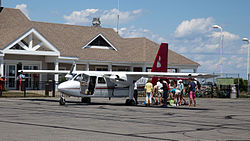
Block Island State Airport
| Block Island State Airport | |
|---|---|

|
|
| Characteristics | |
| ICAO code | KBID |
| IATA code | BID |
| Coordinates | |
| Height above MSL | 33 m (108 ft ) |
| Basic data | |
| opening | 1950 |
| operator | Rhode Island Airport Corp. |
| surface | 55 ha |
| Passengers | 9821 |
| Flight movements |
16,503 |
| Start-and runway | |
| 10/28 | 763 m × 30 m asphalt |
The airfield block Iceland ( IATA: BID; ICAO: KBID ) is a government airfield on block Iceland , Rhode Iceland . The airfield is mainly served by general aviation ; however, there is also regular flight operations.
According to records of the American aviation authority , the airfield had 9821 newcomers in 2010.
Infrastructure and planes
The airfield covers an area of 55 hectares , and is at an altitude of 33 meters above sea level . The asphalt runway is designated 10/28, is 763 meters long and 30 meters wide.
Between September 2009 and August 2010 there were 16,503 aircraft movements (61% general aviation, 38% air taxi and 1% military).
Airlines and destinations
| airline | Destinations |
|---|---|
| Cape Air | Providence |
| New England Airlines | Westerly |