Dabolim Airport
| Goa International Airport Indian Naval Station Hansa |
|
|---|---|

|
|
| Characteristics | |
| ICAO code | VOGO |
| IATA code | GOI |
| Coordinates | |
| Height above MSL | 56 m (184 ft )
|
| Start-and runway | |
| 08/26 | 3460 m × 45 m asphalt |
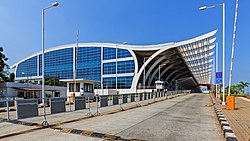
The Dabolim airport and officially Goa International Airport ( Konkani : दाबोळी विमानतळ to Portuguese time as a Aeroporto General Bernard Guedes called) is a as an international commercial airport civil mitgenutzter military airfield of the Indian Navy in the Indian state of Goa , which the device under the name of Indian Naval Station Hansa ( INS Hansa for short ) is used as a land base for carrier-based fixed-wing aircraft and other non-airborne fixed-wing aircraft. The Indian Naval Aviation Museum is also located in Dabolim.
history
The airfield was built in the early 1950s on 100 hectares by the administration of Portuguese India . It served until December 18, 1961 as the home airport of the Portuguese airline Transportes Aéreos da Índia Portuguesa (TAIP), which also offered connections from the Portuguese colony to Mozambique and Lisbon .

At the end of 1961, the airport, which was largely destroyed by bombing and which was renamed Aeroporto General Bérnard Guedes at that time , came under the control of the Indian Navy (IN) as a result of the annexation of the Portuguese colonial territory by India . The interior of the Navy was on September 5, 1961 in the state of Tamil Nadu located Sulur Air Force Base of the Indian Air Force emerged (IAF) and was transferred on 18 June 1964 following Dabolim.
At that time the runway was less than 2,400 m long. It was repaired and made jettable by 1966, which enabled the resumption of civil passenger air traffic by what would later become Indian Airlines in 1966 . In the 1980s, Condor was the first foreign charter airline to include Goa in its flight schedule .
location
The airport is located near the city of Vasco da Gama .
The tower (TWR) sends and receives on the frequency 118.1 MHz . The airport has various navigation aids. The non-directional radio beacon (NDB) transmits on the frequency 274 kHz with the identifier: GO . The rotating radio beacon (VOR) transmits on frequency 113.6 MHz with the identifier GGO . A distance measuring equipment (DME) is present. According to ASN , several accidents are known to have occurred near the airport.
Web links
- Airport data in the Aviation Safety Network (English)
- Airport data in flightstats.com (English)
- Airport data on World Aero Data ( 2006 )
- Airport details In The Airport Guide