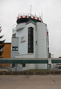
Padua Airport
| Padua Airport | |
|---|---|

|
|
| Characteristics | |
| ICAO code | LIPU |
| IATA code | QPA |
| Coordinates | |
| Height above MSL | 13 m (43 ft ) |
| Transport links | |
| Distance from the city center | 2 km southwest of Padua city center |
| Street | Corso Australia, Via Sorio |
| Local transport | bus |
| Basic data | |
| opening | 1916 |
| operator | Aeroporto Civile di Padova SpA |
| Start-and runway | |
| 04/22 | 1122 m × 30 m asphalt |
The Padua Airport ( IATA : QPA , ICAO : LIPU ; . It Aeroporto Civile di Padova "Gino Allegri" ) located in the northern Italian Veneto , about two kilometers southwest of the center of Padua .
Infrastructure and use
The airport is in the urban area of Padua on Via Sorio, near Brusegnana. It has an asphalt runway (04/22) around 1100 meters long . A 600-meter-long grass runway runs parallel to this. The main handling area is located in the north, other small aprons and other facilities surround the runway. The airfield is especially by local aero clubs and their flight schools as well as from the general aviation use.
Transport links
Urban APS buses number 6 and 12 run to the city center every 15 minutes. The journey time to the train station is ten minutes. There is a taxi rank at the main entrance. The airfield has a parking lot for around 120 vehicles, some short-term parking spaces are located at the control tower. Well-known spas in the Euganean thermal spa area such as Abano Terme or Montegrotto Terme are easy to reach.
history
Padua has a long aviation tradition. On August 22, 1808, the aviation pioneers Pasquale Andreoli and Francesco Zambeccari rose from the Prato della Valle with their hot air balloon . In the course of time, several others followed her there, such as Teresa Garnerin on July 31, 1825. On February 18, 1910, Leonino da Zara founded the Aero Club d'Italia in Padua and immediately afterwards the Padua Aero Club . The city's first airfield was established near Bovolenta in 1910 . During the First World War several military airfields were built near Padua: San Pelagio, Isola di Carturo, Grossa di Gazzo, Gazzo, Arquà Petrarca, San Pietro in Gù and Brusegana. Today's Padua airport emerged from the latter. Until the Second World War , Padua was the headquarters of a major unit of the Italian Air Force ( 2ª Squadra Aerea ). After the war, the headquarters of a large anti-aircraft missile unit ( 1ª Brigata Aerea ) and an army aviation unit were located here for a long time . In 1987 the civil use of the airfield was permitted. In 2009, the withdrawal of the remaining military units began.
Others
- The airfield is named after Gino Allegri, an Italian military pilot who had a fatal accident on the San Pelagio airfield near Padua in October 1918.
- Because of its location in the urban area, there are calls for the airfield to be completely closed after the last military units have been withdrawn for noise and safety reasons and to be converted into a large city park.
- The district control point "Padua" of the Italian air traffic control ENAV is not located at the Padua airport, but in Abano Terme .
Web links
- Airport data on World Aero Data ( 2006 )
- Homepage of the airfield
- Aeroclub Padua