Fort King George Historic Site
| Fort King George Historic Site | ||
|---|---|---|
| National Register of Historic Places | ||
|
Reconstruction of Fort King George |
||
|
|
||
| location | east of Darien , McIntosh County , Georgia | |
| Coordinates | 31 ° 21 '53.8 " N , 81 ° 24' 52.4" W | |
| Built | 1726 | |
| NRHP number | 71001101 | |
| The NRHP added | December 9, 1971 | |
The Fort King George Historic Site is a historic site on the site of a former British frontier forts in McIntosh County in the US state of Georgia . It is located about three kilometers east of Darien at the mouth of the Altamaha River . The approximately nine-acre facility is managed by the State Parks & Historic Sites division of the Georgia Department of Natural Resources .
At the time of its construction, the fort was the southernmost fortress of the British colonies in North America and the first British fortress on the Georgian coast. Although it was only occupied for six years until 1727, the fort played an important role in the settlement of Georgia.
history
In the summer of 1719, colonists from Carolina demanded more military protection of the southern border, fearing Spanish and French attacks and Indian raids. The Carolina administration dispatched militia officer Colonel John Barnwell to the border in 1720 . Barnwell requested troops from Great Britain to build a border fort at the strategically important mouth of the Altamaha River, whereupon an approximately 100-strong company of invalids, His Majesty's Independent Company of South Carolina , was sent from London to Charleston . Since the troops fell ill with scurvy during the crossing , Barnwell had to build the planned fort with a small group of boy scouts. Despite all the difficulties, a log house surrounded by earth walls was completed at the end of 1721, which was named Fort King George after King George I and was moved into in spring 1722 by the recovered Independent Company. Further buildings were erected by the end of 1722 and the fort was further fortified with a palisade fence and two bastions. Barnwell organized cattle, implements and seeds for the soldiers to support themselves and so the fort would become a permanent settlement to move the southern border of the British colonies further south. However, the area was also claimed by Spanish Franciscans who had founded the Santo Domingo de Talaje mission station at the mouth of the Altamaha River around 1595, which they had to give up again in 1661. The Spaniards demanded the evacuation of the fortress, but left it with official protests. In 1725 there was a fire in the fort for unknown reasons, so that the fort had to be rebuilt in 1726. Due to the unfavorable location of the fort in a swampy environment, numerous soldiers of the garrison died of malaria , diarrhea or other diseases, so that self-sufficiency or an expansion of the fortress was out of the question and the garrison was withdrawn in 1727.
Not long after the garrison had withdrawn, the British planned a new strategy. In 1736, under the leadership of General James Oglethorpe , Scottish settlers from the Highlands settled in place of the disabled soldiers on the site of the abandoned fort. As the settlers brought their families with them, greater efforts were made to settle the area. Today's Darien emerged from the settlement, making it the second oldest city in Georgia after Savannah .
The original location of the fort was rediscovered in 1932 using historical maps. In 1940, the state acquired the five-acre site and established Fort King George State Park . In 1961, the Georgia Historical Commission took over management of the property, which was renamed Fort King George Historic Site . In 1967 a thorough archaeological investigation of the site took place. Numerous graves and other artifacts were found, but no evidence of the log cabin, confirming statements that the building was demolished by the British and reused elsewhere. In 1970, a small museum was built on the site, which was registered as a historic site on December 9, 1971 in the National Register of Historic Places . From 1988 the fort was reconstructed according to the old building plans and with authentic materials; the reconstruction was completed in 2004. In 2002, donations made it possible to purchase the adjacent property and expand the State Historic Site to almost nine hectares.
investment
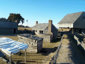
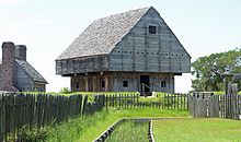
The fort is located on a hill on the north bank of the Altamaha River, which was settled by Indians over 10,000 years ago and by Spanish missionaries in the 17th century. The reconstructed British fort is a triangular structure fortified with earth walls and palisades. The center of the facility is a three-story, twelve-meter-high log house made of cypress wood, next to it there are officers' quarters, a guardhouse and other buildings. The Historic Site contains a museum that shows the history of the fort as well as that of the Guale Indians, the Spanish Mission Santo Domingo de Talaje, the Scottish settlers and the sawmills in the 19th century. To the west of the fort is the fort's cemetery with soldiers' graves, and the ruins of three sawmills are still visible.
Web links
- Website of the Historic Site
- History of the Historic Site
- Fort King George on fortwiki.com
- Fort King George Historic Site on the United States Geological Survey's Geographic Names Information System
Individual evidence
- ^ National Park Service: Survey of Historic Sites and Buildings - Spanish Mission Site. Retrieved July 20, 2011 .
- ↑ Darien History: Highlanders Settle Darien. (No longer available online.) Archived from the original on July 28, 2011 ; Retrieved July 20, 2011 . Info: The archive link was inserted automatically and has not yet been checked. Please check the original and archive link according to the instructions and then remove this notice.
- ↑ Fort King George in the National Register Information System. National Park Service , accessed August 8, 2017.


