
Fort de la Prée

The Fort de La Prée is a fortress that was built from 1625 on the order of Seigneur Jean de Saint-Bonnet de Toiras by the engineers Pierre de Conty d'Argencour and Le Camus on the north coast of the Île de Ré . It is halfway between the communes of La Flotte and Rivedoux-Plage in the Charente-Maritime department .
description
The work consists of a four-pointed star with a bastion at each corner, which are connected by semicircular, inwardly curved curtains (so-called “cul de chaudron”). In front of the bastions there is a glacis with a covered path on the land side . The trenches are only filled with water at high tide. Inside there are some accommodation and farm buildings, a chapel, some coach houses and two powder magazines on the bastions. The gate was originally equipped with a drawbridge and a neck moat , but both of them have now disappeared. The artillery defense could only be carried out by guns above the bank (that is, free-standing on the ramparts). Since the walls consist of massive earthworks that are covered with masonry, there are no casemates with cannon slots. A small, sheltered harbor belongs to the fortress. It is located directly on the Ravelin in front of the gate and can only be used at high tide .
Stones from the ruins of the Abbey of Notre-Dame-de-Ré (also: Notre-Dame de Sainte-Marie-des-Châtelier) were also used for the masonry . This former monastery was in the immediate vicinity of the construction site.
The building was criticized in 1658 by the governor of the island as being too small, as it could only accommodate a crew of 400 men. There is also no well, and the drinking water required had to be collected in cisterns . The facility was reinforced in 1664 on the orders of Jean-Baptiste Colbert , who had an enceinte built. In 1672 the fortress was reinforced by a second enceinte.

After the fortifications of Saint-Martin-de-Ré were completed , the Fort de La Prée was not well regarded as one of the less useful works on the island. Vauban had the land walls leveled in 1684, so that only the glacis with the covered path remains here.
history
The fortress has only proven useful once: when the Duke of Buckingham landed on the island with his troops in 1627, he ignored the small fort, which turned out to be a mistake. In his protection, the French rescue army under the command of Henri de Schomberg landed on the island on an October night in 1627, in order to subsequently drive out the English.
Abandoned for a long time, it was not used again for the military until 1793 and reactivated again in 1875. The final military decommissioning took place in 1934.
During the Second World War , the fort was incorporated into the Atlantic Wall by the Wehrmacht . An artillery observation post was set up for a gun emplacement called “Battery Berta”.
Between 1950 and 1980 the fort served as a rest home for children aged six to ten from the Eure department . At that time it belonged to the “Conseil Général de l'Eure”, as well as some other properties on the island, such as “La Ferme” in front of the fort and “Îlot Normand” in Bois-Plage .
After a wall collapsed at the beginning of the 1980s, the “Comité national des œuvres sociales de l'administration pénitentiaire” (National Committee of the Social Work of the Prison Administration) had the damage repaired by prisoners. Since then, the committee has also owned the fortress.
The facility is open to visitors in summer and cultural events are also held here during this time.
On May 21, 2008, the fortress was added to the list of historical monuments .
gallery
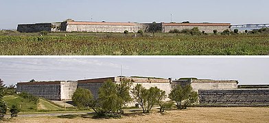
View of the southern walls
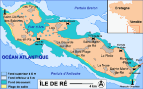
Map of the Île de Ré

Land side bastions


literature
- N. Faucherre, P. Prost, A. Chazette, F. le Blanc: Les fortifications du littoral. La Charente Maritime - Éditions patrimoines et médias October 2000, pp. 50–56, ISBN 2-910137-17-1
Individual evidence
- ↑ Fort de la Prée in the Base Mérimée of the French Ministry of Culture (French)
Web links
Coordinates: 46 ° 10 ′ 51 ″ N , 1 ° 17 ′ 19 ″ W.