
Franche Valeine
| Franche Valeine | ||
 The Franche Valeine near Forgès |
||
| Data | ||
| Water code | FR : P1370510 | |
| location | France , Nouvelle-Aquitaine region | |
| River system | Dordogne | |
| Drain over | Souvigne → Dordogne → Atlantic Ocean | |
| source | in the municipality of Sainte-Fortunade 45 ° 11 ′ 45 ″ N , 1 ° 47 ′ 30 ″ E |
|
| Source height | approx. 520 m | |
| muzzle | above Saint-Chamant in the Souvigne coordinates: 45 ° 8 '43 " N , 1 ° 52' 34" E 45 ° 8 '43 " N , 1 ° 52' 34" E |
|
| Mouth height | approx. 205 m | |
| Height difference | approx. 315 m | |
| Bottom slope | approx. 21 ‰ | |
| length | 15 km | |
| Catchment area | 111 km² | |
The Franche Valeine is a small river in France that runs in the Corrèze department in the Nouvelle-Aquitaine region . It rises in the municipality of Sainte-Fortunade approx. 1 kilometer northwest of Lagarde-Enval , generally drains in a south-easterly direction and after 15 kilometers on the municipal boundary of Forgès and Saint-Chamant reaches the Souvigne as a right tributary , which in turn later flows into the Argentat Dordogne empties.
Places on the river
- Lagarde Enval
- Chantarel (Albussac municipality)
- Albussac
- Grand Champ (municipality of Forgès )
Attractions
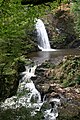
- The Murel Waterfalls ( Cascades de Murel ) are three consecutive waterfalls between Forgès and Albussac .

The Murel cascades: 1st case
The Murel cascades: 1st and 2nd case

The Murel cascades: 2nd case

The Murel cascades: 3rd case


Web links
Commons : Franche Valeine - Collection of images, videos and audio files
Individual evidence
- ↑ a b geoportail.fr (1: 16,000)
- ↑ a b c The information on the length of the river is based on the information on the Franche Valeine from SANDRE (French), accessed on August 22, 2011, rounded to full kilometers.