
Freeport Monrovia
| Freeport Monrovia | |||
|---|---|---|---|
| Data | |||
| UN / LOCODE | LRMLW | ||
| owner | State property | ||
| operator | Monrovia Port Autorithy | ||
| start of building | 1942 | ||
| opening | 1943 | ||
| Port type | seaport | ||
| Total area of the port | 30,000 m² | ||
| Piers / quays | 610 m | ||
| Goods handled | Iron ore , rubber , oil | ||
| Container (TEU) | Container terminal | ||
| Geographic information | |||
| place | Monrovia | ||
| region | Montserrado County | ||
| Country | Liberia | ||
 |
|||
| Coordinates | 6 ° 20 '24 " N , 10 ° 47' 40" W | ||
|
|||

The Freeport Monrovia in the Liberian capital Monrovia is the country's most important seaport.
location
The Freeport Monrovia is located on the west bank of the former Bushrod Island at the mouth of the Mesurado River in the Atlantic . The entrance to the port was marked by the lighthouse on Cape Mesurado , this lighthouse is currently out of order.
history
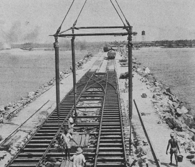
The construction of the port and other military infrastructure was prepared in 1940 at a meeting between US Admiral LeBreton and the Liberian State Secretary Simpson . The port was planned by the US Navy as a protective port on the West African coast during the Second World War and built by local construction workers under the guidance of US civil engineers. The port was transferred to civil use as a free port in 1948 and is Liberia's main port. The main imports are building materials of all kinds, fuels, industrial and commercial goods and vehicles. In return, Liberia mainly produces iron ore, rubber and rubber products (car tires and tubes), tropical wood, raw coffee and cocoa. During the civil war, the port was raided several times and supplies plundered. The port has a very high priority in the reconstruction of the country.
description
The approximately 300 hectare large harbor basin was created through the construction of two piers (embankments of 2359 m and 2200 m length respectively), which approach each other at an angle of about 70 degrees. The entrance is at the virtual intersection of the two dams, about 2 km from the coast. There is a roadstead in front of the entrance . The main pier is a bank zone fortified with concrete walls and has a length of 610 m.
In the northern part of the port there is the area of the cold stores and the pier for the fishing vessels. In the middle part of the port, the bong mining train ends at the loading terminal for iron ore , currently the most important commodity in the country. The track network branches out in the port area and also allows the rail-bound transport of containers . In the southern port area, an approximately 800 m long steel bridge with a pipeline marks the terminal for the oil tankers . The port is directly connected to a nearly 10 km long pipeline with the district Greenville contained oil refinery of the Liberia Petroleum Refining Company connected. Their operation has been stopped since 1982, as a result of the civil war . The port area also includes several service companies and a shipyard with a dock .
Several logistics companies have settled in the area around the port. The port area has numerous warehouses and container spaces and is strictly guarded. Immediately north of the port is the central warehouse for aid deliveries and transport technology set up by the UN organizations.
Port modernization
The Liberian government has drawn up plans with the Portland Port Authority to modernize the port. The Dutch specialist company for container terminals APM Terminals from The Hague has taken over a public-private partnership agreement with the aim of building and operating a modern container terminal.
administration
The Monrovia Port Autorithy is the Port Authority since 1970 and owner of the nationalized harbor. In the port can cargo ships , including container ships , and create smaller oil tankers. Occasionally, cruise ships and warships also stop at the port.
Remarks
- ↑ Port accident: The fully loaded container ship "TORM ALEXANDRA" capsized on July 25, 2001 at the main pier and blocked it until May 8, 2009. The ship could be erected again with a special crane, but it was intended to be scrapped. There are currently around 4 smaller freighters lying aground in the harbor basin.
Individual evidence
- ^ Liberia, construction of the port 1942. In: US Navy Archive Image archive of naval bases of the Second World War. Retrieved October 20, 2010 . (English)
- ↑ a b c Monrovia Port Information. In: Reederei OT AFRICA LINE - online portal. Retrieved October 21, 2010 . (English)