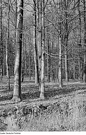
Friedewald, Moritzburg pond area and Lößnitz
The landscape protection area Friedewald and Moritzburger Teichgebiet (d 17) is a landscape above the Dresden Elbe valley widening , on the western edge of the Lausitzer Platte . It extends over the territories of the municipalities of Moritzburg and Weinböhla and the cities of Coswig and Radeburg .

Both the Friedewald and the Moritzburg pond area , originally with 40 ponds, were created around 1500 under Duke Georg the Bearded . The name "Friedewald" describes the aforementioned as "enclosed forest". The game was kept together for hunting in the almost completely walled area.
In the southeast, the area of the previously separately managed Lößnitz landscape protection area within the city of Radebeul is immediately adjacent , the code d33 of which is no longer listed. The combined nature reserve Friedewald, Moritzburger Teichgebiet and Lößnitz can still be found under d17 .
Today's Moritzburg district Friedewald , which consists of Dippelsdorf and Buchholz , was named after the forest area . Other places in the area are Cunnertswalde , Steinbach , Neuer Cultivation , Kreyern and Auer .
Characteristic

In the landscape protection area, as the name suggests, two parts of the cultural landscape that are worth protecting come together - the forest, which is intended as a commercial and recreational forest, and the pond landscape, which is also managed and at the same time serves for recreation. In accordance with Section 26 of the Federal Nature Conservation Act , all measures here are geared towards the preservation and development of nature in order to ensure the performance and functionality of the area. The Moritzburg pond area is also close to the nationally important bird flight axis in the Elbe area. The ponds are water-bound resting places for migratory birds . The entire area is also a large archaeological site with Stone Age , Bronze Age and Iron Age settlements and graves.
The proximity to the conurbation in the Elbe valley , the role of Moritzburg as a center of tourism and as a center of equestrian sports result in a multitude of conflicts and overuse of the Friedewald and the pond area. Forest owners, riders, hikers, cycle tourists, ornithologists, fishermen, archaeologists and bathers are in constant conflict with each other about the preferred protected property.
An important measure to protect nature was the separation of the Moritzburger Frauenteich from the LSG and the classification as a nature reserve (NSG), which largely limits the perception of "human interests" in this area. The area around the Frauenteich has been designated as a European bird sanctuary by the EU and included in the Natura 2000 program. It is also classified as an Important Bird Area .
literature
- Ordinance of the district office of Meißen on the amendment of the law and new delimitation of the landscape protection area "Friedewald, Moritzburger Teichlandschaft and Lößnitz" from December 17, 2012.
Web links
Individual evidence
- ↑ svglw. Conception, optimization and model implementation of a multifunctional recreational forest ( page no longer available , search in web archives ) Info: The link was automatically marked as defective. Please check the link according to the instructions and then remove this notice. by Henrik Thode, Tharandt;
