Göksu (Seyhan)
| Göksu | ||
| Data | ||
| location | Adana , Kahramanmaraş , Kayseri ( Turkey ) | |
| River system | Seyhan | |
| Drain over | Seyhan → Mediterranean | |
| Headwaters | in the Tahtalı Mountains 38 ° 38 ′ 46 ″ N , 36 ° 38 ′ 53 ″ E |
|
| Source height | approx. 2000 m | |
| Association with |
Zamantı near Aladağ / Adana zum Seyhan Coordinates: 37 ° 36 '22 " N , 35 ° 35' 6" E 37 ° 36 '22 " N , 35 ° 35' 6" E |
|
| Mouth height | 323 m | |
| Height difference | approx. 1677 m | |
| Bottom slope | approx. 8.4 ‰ | |
| length | approx. 200 km | |
| Reservoirs flowed through |
Gökkaya Dam , Feke-2 Dam , Quantity Dam , Köprü Dam |
|
| Small towns | Sarız , Feke | |
| Communities | Himmetli | |
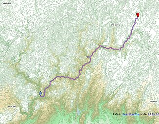
The Göksu (means “blue water”) flowing through eastern Cilicia is the shorter and eastern source river of the Seyhan after the western Zamantı river .
In the 2000s, the river's hydropower was developed and several hydropower plants and dams were built along the course of the river. The Göksu has its source in the Tahtalı Mountains northeast of Sarız in the Kayseri Province . It flows mainly in a south-westerly direction through Sarız. In Central Taurus above Himmetli is located Gökkaya Dam . Further smaller dams are located downstream. The Göksu passes the district town of Feke . Below Feke the flux by three high RCC - gravity dams ( Feke-2-dam , Volume dam and Köprü dam almost accumulated) over the entire length. Finally, about 80 km before the city of Adana near Aladağ in the Adana province , it meets the main source river Zamantı and thus forms the river Seyhan, which later flows into the Mediterranean at Tarsus .
