
Goering stone
| Goering stone | ||
|---|---|---|
 The Göringer Stein seen from the east |
||
| height | 317 m above sea level HN | |
| location | Thuringia ( Germany ) | |
| Mountains | Thuringian Forest | |
| Coordinates | 50 ° 59 '38 " N , 10 ° 10' 36" E | |
|
||
| rock | Zechstein via Rotliegend | |
| particularities | 180 ° view to the north | |

The Göringer Stein has a summit height of 317 m above sea level. NN and is one of the westernmost mountains of the Thuringian Forest . The larger western part is located in the municipality of Gerstungen , Lauchröden in the Wartburg district in Thuringia , the eastern part is in the Göringen district of the Wartburg town of Eisenach .
geography
The mountain on the western edge of the Thuringian Forest, which is not forested in the Göringer part and is otherwise covered with beech forest, extends right up to the steep bank of the Werra . The mountain rises up to 120 meters above the floodplain, it has a steep slope in the north and west, there is a moderate incline in the east, the area could therefore be used for arable farming and fruit tree planting; in the southwestern part the slope merges into the saddle to the nearby Stechberg . This area is also used for agriculture.
history
The Göringer Stein is a legendary place. A castle of the same name is said to have once stood on its summit.
The Brandenburg Castle Hill is only 500 meters away in the direction of Lauchröden . In the Middle Ages, an old road ran past the flank of the mountain in the direction of Eisenach am Göringer Stein, the ravines of which can still be seen as ditches in the western slope. She was monitored by the Brandenburg.
The Göringer Stein was probably deforested by the middle of the 19th century. Beginning with the steep slopes, which were only suitable for grazing with sheep, a new forest was afforested. One miner believed that there might be veins hidden in the mountain; he received an extension of his concession for the Göringer copper shale mining. The remains of the tunnel mouth hole can still be seen in the forest not far from Göringen. On the summit there is an exposed rock section, it was popular as a place for excursions. The monogram CA, the year 1878 and a crown were carved into a stone on the south side - it is a tribute and a "gift" for the then father of the country, Grand Duke Carl Alexander, on the occasion of the 25th anniversary of the reign in 1878.
Mining
Zechsteiner ore (sand ore and copper slate ) has been mined in the Eisenach area and also at Göringer Stein since the Middle Ages . The tunnel in Göringer Stein had a heyday in the 1850s and was operated until 1906, most recently by the United Thuringian Copper Construction Union .
tourism
The Göringer Stein and its surroundings were a popular destination next to the Brandenburg in the 19th century. Until the Werra bridge in Lauchröden was blown up in March 1945, both places could be easily reached by train from the Herleshausen stop of the Thuringian Railway . The reconstruction of the bridge was prevented by the conditions at the later zone border , and tourism was prohibited due to the location in the 500-meter restricted strip . From Lauchröden, Herleshausen and Göringen, new hiking trails have been leading there since the fall of the Wall . Both places can now be easily reached again by train from Herleshausen. At the foot of the Göringer Stein is the former Göringen river barrage , today known colloquially as the “Blue Wonder”. It is a former border barrier that is now, partially dismantled, used as a pedestrian bridge over the Werra. From the edge of the forest, if the weather conditions are good, there are opportunities to view the Kielforst and the Thuringian Gate with the Werra Valley Bridge at Hörschel .
Impressions

View from the north (Herleshausen)

Rock section at the summit
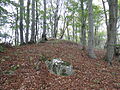
highest point of the mountain with memorial stone for Grand Duke Carl Alexander (2014)

Memorial stone for Grand Duke Carl Alexander (close-up, 1991)

The former upper entrance to the Göringer Kupferstollen (2014)


literature
- Gerd Bergmann, Hans Heuse a. a .: Our village Lauchröden. Compilation of local history contributions . Ed .: Municipality of Lauchröden. Lauchröden 1994, p. 104 .
- Karl-Heinz Schmedding: The poet of the Werra valley JHCh. Heusinger . In: Heimatblätter '91 of the Eisenacher country . 1991. p. 59. (= EP Report 1)
Web links
Individual evidence
- ↑ Official topographic maps of Thuringia 1: 10,000. Wartburgkreis, district of Gotha, district-free city of Eisenach . In: Thuringian Land Survey Office (Hrsg.): CD-ROM series Top10 . CD 2. Erfurt 1999.