
Stechberg
| Stechberg | ||
|---|---|---|
 The Stechberg |
||
| height | 342.7 m above sea level HN | |
| location | Thuringia ( Germany ) | |
| Mountains | Thuringian Forest | |
| Coordinates | 50 ° 59 '17 " N , 10 ° 10' 25" E | |
|
||
| rock | Zechstein via Rotliegend | |
| particularities | 360 ° view | |

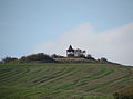
At 342.7 m, the Stechberg is the westernmost mountain in the Thuringian Forest and is located in the municipality of Gerstungen , Lauchröden district in the Wartburg district in Thuringia .
geography
The unforested, cone-shaped Stechberg rises on the western edge of the Thuringian Forest just under 1 km east of Lauchröden . It is located on the edge of the Werra valley . To the north lies the legendary Göringer Stein and the Burgberg of Brandenburg as an offshoot of the Stechberg. To the south follows the Eltetal and the Böller forest area . The mountain can be reached via hiking and field paths directly from Lauchröden or from nearby Brandenburg in an easterly direction.
history
The Stechberg is located about 700 m south of the Brandenburg and is said to have served the castle crew as an additional watchpoint. During the GDR era, there was a Red Army observation point on the Stechberg , which has now fallen into disrepair. After 1990, a refuge was built on the still existing, accessible ruins of the bunker.
view
From the top of the treeless Stechberg there are beautiful views in good visibility. In the west you can find the ruins of the Brandenburg, behind it Herleshausen and the mountains of the Ringgau with the striking castle hill of the ruin Brandenfels near Markershausen , in the north the Göringer Stein and the Kielforst with the Werra valley bridge rise near Hörschel on the Hessian-Thuringian border. In the east and south you can look over the Eltetal to the Böller and the forests and fields from Unterellen to Marksuhl .
The summit plateau with the refuge

View from the summit to the Hörschel bridge over the Werra valley
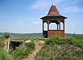
Summit with refuge and remains of bunkers


