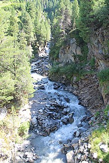
Gaisbergbach (Gurgler Ache)
| Gaisbergbach | ||
|
The Gaisbergbach just before the mouth |
||
| Data | ||
| Water code | AT : 2-8-92-30-6 | |
| location | Ötztal Alps , Imst district , Tyrol | |
| River system | Danube | |
| Drain over | Gurgler Ache → Ötztaler Ache → Inn → Danube → Black Sea | |
| origin |
Gaisbergferner 46 ° 49 ′ 36 ″ N , 11 ° 4 ′ 9 ″ E |
|
| Source height | at 2460 m above sea level A. | |
| muzzle | Above Obergurgl from the right into the Gurgler Ache Coordinates: 46 ° 51 '49 " N , 11 ° 1' 5" E 46 ° 51 '49 " N , 11 ° 1' 5" E |
|
| Mouth height | 1896 m above sea level A. | |
| Height difference | 564 m | |
| Bottom slope | 12% | |
| length | 4.6 km | |
| Catchment area | 7.44 km² | |
| Communities | Soelden | |
The Gaisbergbach is a right tributary to the Gurgler Ache in Tyrol .
course
The Gaisbergbach rises from the Gaisbergferner at around 2460 m above sea level. A. and then runs in a north-westerly direction through the Gaisbergtal before it joins the Gurgler Ache below the Zirbenalm from the right. At about 2240 m above sea level. A. the stream is dammed up for a snow-making pond.
The natural catchment area of the Gaisbergbach is 7.44 km², of which 1.79 km² (24%) are glaciated (as of 1988). The highest point in the catchment area is the Hochfirst at 3403 m above sea level. A.
Web links
Commons : Gaisbergbach - Collection of images, videos and audio files
Individual evidence
- ↑ a b c TIRIS - Tyrolean spatial information system
- ↑ https://portal.tirol.gv.at/wisSrvPublic/wis/wbo_wb_auszug_pdf.aspx?ATTR=Y&TREE=Y&PICTURE=N&ANL_ID=T20527112R3&TYPE=O
- ^ Max H. Fink, Otto Moog, Reinhard Wimmer: Flowing waters - natural areas of Austria . Federal Environment Agency, Monographs Volume 128, Vienna 2000, p. 48 ( PDF; 475 kB )
