Gandesa
| Gandesa municipality | ||
|---|---|---|
| coat of arms | Map of Spain | |

|
|
|
| Basic data | ||
| Autonomous Community : | Catalonia | |
| Province : | Tarragona | |
| Comarca : | Terra Alta | |
| Coordinates | 41 ° 3 ' N , 0 ° 26' E | |
| Height : | 168 msnm | |
| Area : | 71.2 km² | |
| Residents : | 3,064 (Jan 1, 2019) | |
| Population density : | 43.03 inhabitants / km² | |
| Municipality number ( INE ): | 43064 | |
| administration | ||
| Official language : | Castilian , Catalan | |
| Mayor : | Miquel J. Aubà i Fleix | |
| Website : | www.gandesa.altanet.org | |
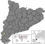
| Location of the municipality | ||

|
||
Gandesa is a Catalan city in the province of Tarragona in northeastern Spain . It is the capital of the Comarca Terra Alta .
Geographical location
Gandesa is about 70 kilometers west of Tarragona .
economy
Viticulture is a major industry in the city. In addition, almonds and olives are grown. The industrial focus is on the further processing of these products.
history
Gandesa was the scene of major battles of the Carlist Wars and the Battle of the Ebro in the Spanish Civil War .
Attractions
The cooperative's winery was built in 1919 by Cèsar Martinell in the style of a “wine cathedral”.
Web links
Commons : Gandesa - collection of images, videos and audio files
Individual evidence
- ↑ Cifras oficiales de población resultantes de la revisión del Padrón municipal a 1 de enero . Population statistics from the Instituto Nacional de Estadística (population update).
