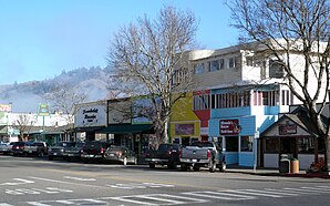
Garberville
|
|
This article was on the basis of substantive defects quality assurance side of the project USA entered. Help bring the quality of this article to an acceptable level and take part in the discussion ! A closer description on the resolving issues is missing. |
| Garberville | ||
|---|---|---|
 Downtown Garberville |
||
| Location in California | ||
|
|
||
| Basic data | ||
| Foundation : | 1853 | |
| State : | United States | |
| State : | California | |
| County : | Humboldt County | |
| Coordinates : | 40 ° 6 ′ N , 123 ° 48 ′ W | |
| Time zone : | Pacific ( UTC − 8 / −7 ) | |
| Residents : | 2,403 (as of: 2000) | |
| Height : | 163 m | |
| Postal code : | 95542 | |
| Area code : | +1 707 | |
| FIPS : | 06-28154 | |
| GNIS ID : | 224036 | |
Garberville is a small town in the US state of California in southern Humboldt County . The small town, 200 miles (320 km) north of San Francisco , is also the start of California Route 1.
The place was founded in 1853 under the name Dogtown . Today it serves as a recreation area. The Humboldt State Redwoods Park and the nearby "Avenue of the Giants", an avenue of sequoia trees, are well worth seeing. It is also noteworthy that the place is granted up to 300 sunny days per year.

