Gardendale, Alabama
| Gardendale | |
|---|---|
|
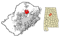
Location in County and Alabama
|
|
| Basic data | |
| Foundation : | 1825 |
| State : | United States |
| State : | Alabama |
| County : | Jefferson County |
| Coordinates : | 33 ° 39 ′ N , 86 ° 49 ′ W |
| Time zone : | Central ( UTC − 6 / −5 ) |
| Residents : | 13,893 (as of 2010) |
| Population density : | 298.8 inhabitants per km 2 |
| Area : | 46.5 km 2 (approx. 18 mi 2 ) of which 46.5 km 2 (approx. 18 mi 2 ) is land |
| Height : | 207 m |
| Postal code : | 35071 |
| Area code : | +1 205 |
| FIPS : | 01-29056 |
| GNIS ID : | 0118823 |
Gardendale is a city in Jefferson County in the US state of Alabama . It had 13,893 inhabitants at the 2010 United States Census ; the estimated population for 2015 was 13,711. The area of Gardendale is 46.5 km².
geography
Gardendale is on Interstate 65 , one of the three main routes between the Midwest and the Gulf Coast. This long-distance connection runs through the city in a north-south direction, as does US Highway 31 . Interstate 22 , which was built just a few years ago, branches off from I-65 at Gardendale and leads northwest to Memphis . The main westbound connections in the city are Fieldstown Road, Tarrant Road and Mt. Olive Road, heading west from US-31. The city is located in the middle of an area that once produced large amounts of coal, at the southwestern end of one of the ridge lines of the Appalachian Mountains that stretches from eastern Tennessee to northeastern Alabama. Several abandoned coal mines characterize the area as well as reforested opencast mines. There are no major bodies of water through Gardendale, but several streams flow into the Locust Fork of the Black Warrior River , which flows north and west of the city. Most of the eastern and northeastern part of the urban area is rocky and hilly and criss-crossed with gorges. This part of Gardendale is sparsely populated and has only limited access to roads.
traffic
The only railroad nearby passes Gardendale east; it is used for freight traffic and is not used by passenger trains. The nearest Amtrak train station is in Birmingham, some 10 miles south . Not far from there is also Birmingham International Airport for commercial air traffic.
Demographics
At the time of the 2010 United States Census, Gardendale was inhabited by 13,893 people. There were 6,040 housing units. The population of Gardendale was 88.4% white and 8.6% black or African American .
Web links
Individual evidence
- ↑ Quickfacts: Gardendale, Alabama. In: census.gov. United States Census Bureau , accessed April 8, 2017 .
