
Gavurkale
Coordinates: 39 ° 31 ′ 53 ″ N , 32 ° 33 ′ 32 ″ E


Gavurkale , also Gavur Kalesi ( Turkish for castle of the infidels ) is the name of a hill in Central Anatolia on which a Hittite rock relief and architectural remains from different periods have been found. Gavurkale is located 60 kilometers southwest of Ankara , about two kilometers northwest of the village of Dereköy in Haymana County . The hill is at an altitude of about 1150 meters above sea level and rises 60 meters above the surrounding area.
Reliefs
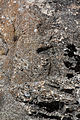
The summit of the hill is an artificial plateau of about 35 × 37 meters, the south side of which is an approximately twelve-meter-high, steeply sloping rock face. The figures of three deities are carved into this wall. On the right are two male gods, 3.40 and 3.65 meters high, respectively. They are eight to twelve centimeters carved out of the rock and in poor condition. The two people wear the well-known pointed shoes and the short, wrapped skirt of the Hittite warriors. Incised decorative hems on the front and bottom of the skirt can be seen. A sword is carried over this, the sickle-shaped handle of which protrudes forward over the skirt and protrudes plastically. The sheath over the body is only incised and crosses - incorrectly - with the hem of the skirt. The left arm is bent, the hand in front of the chest, while the right arm is held up in a greeting gesture. The headwear consists of the pointed hat characteristic of gods, which is decorated with horns on the front and back. Their number can no longer be determined with certainty due to severe weathering. The figure on the left is beardless, the figure on the right has a beard, probably a braided ceremonial beard . The end of a long braid of hair can be seen behind the left elbow of the god on the right.
To the left of the two monumental gods, separated by an almost vertical gap, about 3.20 meters high, and thus 2.40 meters higher than the two male figures, a seated female deity can be seen. Its height is 2.40 meters, the relief is only worked out in outline. She sits on a throne, which is only represented by a carved angle line. The figure wears a long robe, on the head a wheel hood depicted on the side . From there a braid or veil hangs down over the back. The two arms are stretched forward, one holds a vessel, the other the symbol of salvation. All these features identify the figure as a goddess. The interpretation of the headgear as a pointed cap and thus the figure as a male deity is rejected by Kay Kohlmeyer , among others, due to the proportions and the lack of horns.
To the left of the seated goddess, at the same distance as the reliefs of the gods, there is a smooth niche of about 6 × 4 meters in the rock wall. Their function can only be assumed. Kohlmeyer suggests that it either contained further reliefs that were later removed or that it was intended to accommodate moving images of gods. In front of it, as with the images of male deities, a bench carved out of the rock can be seen. By comparing it with the rock sanctuary of Yazılıkaya , in front of whose reliefs similar workings can be seen, one can assume that it was intended for ritual acts, such as the making of sacrifices.
Since the reliefs lack any inscriptions, attempts to identify the gods are only speculative. However, due to stylistic comparisons and the type of masonry, the reliefs can be dated to the time of the Hittite Empire (approx. 1350–1200 BC).

Reliefs

Male gods
Seated goddess

Empty niche, the goddess at the top right


architecture
The platform on the hill, the south side of which forms the relief wall, is bounded or supported by walls in an approximately rectangular shape. They are created in a mixture of Cyclopean ashlars and polygonal blocks with a tight joint, which makes the dating to the Hittite period seem certain. On the south-western slope below the screen there are remains of the wall, which, according to Hans Henning von der Osten , the first excavator of Gavurkale (1930), supported a processional path in three terraces. Further south, about 35 meters from the reliefs, the foundations of a rectangular room, perhaps a tower, with adjoining walls were found.
A rectangular chamber with false vaults and internal dimensions of 3.00 × 4.65 meters has been preserved in the north wall of the summit plateau . The entrance is an opening measuring 1.10 × 1.75 meters on the north side. The original interior of the chamber can no longer be reconstructed; it was rebuilt, presumably in Phrygian times , into a passage to the surface of the summit plateau. The south wall of the chamber was broken through and a staircase was built in. The door stop and the bolt hole in the entrance were probably only created during this renovation phase, as otherwise the chamber, which can only be locked from the inside, would have had to have a second entrance. According to an interpretation by the Turkish archaeologist Ekrem Akurgal , the evidence of which is doubted, the term burial chamber has become natural for the room. Other remains of walls on all the slopes of the hill are generally considered to be Phrygian fortification walls with towers. The excavations of the Danish archaeologist Stephen Lumsden in the 1990s uncovered a large number of them, also numerous widely scattered architectural fragments that can be assigned to the Hittite structure on and around the summit. This was therefore probably more extensive and complex than the East had assumed. Traces of a settlement from the Hittite or Phrygian times have not yet been found. Sparse small finds from Roman and Byzantine times indicate a later use.

Relief wall with adjoining Cyclops wall, further wall fragments in the foreground

South-east corner of the summit plateau from the east

So-called burial chamber

Entrance to the Chamber


Research history
The French Georges Perrot and Edmond Guillaume were the first western visitors to the hill in 1861, they only reported on the two male figures. The American orientalist Albert T. Olmstead discovered the relief of the female deity in 1907/08, but did not publish the find. The first excavations were carried out in 1930 by Hans Henning von der Osten and Erich Friedrich Schmidt from the Oriental Institute of Chicago . Von der Osten made the first plan of the hill and suggested reconstruction. Kay Kohlmeyer visited the place in the late 1970s and published a detailed description. In the years 1993-1998 Stephen Lumsden carried out extensive surveys and excavations on the Gavurkale and the surrounding area on behalf of Bilkent University in Ankara . Finally, in 2005 Horst Ehringhaus provided further documentation of the works in his book on the rock reliefs of the Hittite Empire.
literature
- Kay Kohlmeyer : Rock paintings from the Hittite Empire. In: Acta Praehistorica et Archaeologica 15 (1983) pp. 43-48
- Stephen Lumsden: Investigations at a Hittite Sacred Place In: Recent Developments in Hittite Archeology and History: Papers in Memory of Hans G. Güterbock . Eisenbrauns 2002 pp. 111–125 ISBN 978-1-57506-053-8 ( limited preview in Google book search)
- Horst Ehringhaus : gods, rulers, inscriptions. The rock reliefs of the Hittite Empire in Turkey. Zabern, Mainz 2005, ISBN 3-8053-3469-9 , pp. 11-14
Web links
- Gavurkale (Turkish, accessed July 8, 2012)
- hittitemonuments.com

Great Empire: Beyköy | Ermenek | Fıraktın | Gavurkale | Hanyeri | Hatip | Hemite | İmamkullu | Carabel | Keben | Malkaya | Manisa | Meydancıkkale | Nişantaş | Sirkeli | Suratkaya | Taçın | Taşçı | Yazılıkaya
Period of the late Hittite small states: Bulgarian Army | Burunkaya | Gökbez | Gürün | Hisarçık | İvriz | Karaburna | Karadağ | Karasu | Kızıldağ | Kötükale | Kuşçu-Boyacı | Malpınar | Midas Şehri | Şırzı | Suvasa | Tanır | Topada