
George Rogers Clark Memorial Bridge
Coordinates: 38 ° 15 ′ 49 ″ N , 85 ° 45 ′ 1 ″ W.
| George Rogers Clark Memorial Bridge | ||
|---|---|---|
 |
||
| use |
|
|
| Crossing of | Ohio River | |
| place |
Louisville, Kentucky and Jeffersonville, Indiana |
|
| Entertained by | Kentucky Transportation Cabinet | |
| construction | Truss bridge | |
| overall length | 1753 m (main bridge 1140 m) | |
| width | 17 m | |
| Longest span | 250 m | |
| Clear height | 22 m | |
| building-costs | 4.8 million US dollars | |
| opening | 1929 | |
| planner |
Modjeski & Masters Paul Philippe Cret |
|
| location | ||
|
||
_location_map.svg)
The George Rogers Clark Memorial Bridge , formerly the Louisville Municipal Bridge , is a four-lane road bridge over the Ohio River between Louisville , Kentucky and Jeffersonville , Indiana . The truss bridge designed by Modjeski & Masters was the first road link between Kentucky and Indiana in Louisville and has been part of US Highway 31 , which connects Michigan in the north with Alabama in the south, since it opened in 1929 . It is operated by the Kentucky Transportation Cabinet (KYTC) and is named after the founder of Louisville, George Rogers Clark . The traffic volume in 2018 was 14,800 vehicles per day.
Due to its importance for the early development of the state highways in Kentucky and Indiana, as well as the architectural achievements of the architect Paul Philippe Cret , who designed the pylons of the driveways and the adjoining administration building in Art Deco , the building was named the Louisville Municipal Bridge in 1984 , Pylons and Administration Building listed on the National Register of Historic Places (NRHP #: 84001578).
history

The Ohio forms the northern border of the state of Kentucky over 1000 km in length as well as the northern city limit of Louisville, which developed from early settlements on the south bank of the Falls of the Ohio . To the north there were only ferry connections to the smaller towns of New Albany , Clarksville and Jeffersonville in Indiana until the 19th century . The first bridges over the river were built after the American Civil War (1861-1865) by the expanding railroad companies in North America . The Fourteenth Street Bridge to Clarksville, completed in 1870 , had narrow paths for pedestrians, but it wasn't until the Kentucky & Indiana Terminal Bridge to New Albany, built in 1886 downstream to the west, had sufficiently wide lanes for wagons on the outside . Another railway bridge was built upstream in 1895 with the Big Four Bridge to Jeffersonville.
With the advent of motorized road traffic in the early 20th century and the development of the US highways system in the 1920s, the need arose for an adequate road bridge over the Ohio. After approval by the Kentucky General Assembly in 1926, the city of Louisville set up the Louisville Bridge Commission , which in turn entrusted the engineering firm Modjeski & Masters with the design and choice of location. Ralph Modjeski and Frank M. Masters , in collaboration with the architect Paul Philippe Cret, designed a 1.75 km long four - lane truss bridge that was to connect Second Street in Louisville with the southern tip of Jeffersonville. The financing could be secured until the beginning of 1928 by issuing a toll financed municipal bond (toll revenue bond) . Construction work on the bridge piers began in June 1928 by the Vang Construction Company and the construction of the superstructure took place between December 1928 and July 1929 by the American Bridge Company ; the official opening of the Louisville Municipal Bridge took place in the fall of that year.
After 17 years, the municipal loan was paid and the toll could be lifted on November 1, 1946. In the course of this, the bridge became the property of the state of Kentucky, the authority responsible today is the Kentucky Transportation Cabinet (KYTC). To relieve the bridge, the six-lane John F. Kennedy Memorial Bridge was built upstream by 1963 and another six-lane road bridge with the neighboring Abraham Lincoln Bridge was built by 2015 , with both bridges now each having six lanes of Interstate 65 . Renamed the George Rogers Clark Memorial Bridge in 1949 , the first road bridge has spanned US Highway 31 across the Ohio since it opened , with a daily traffic volume of 14,800 vehicles in 2018.
description
The 1753 m long structure is divided into the main bridge (1140 m) over the Ohio and the adjoining driveways on the Kentucky (256 m) and the Indian side (357 m). The beginning of the driveways is flanked by about 10 m high pylons that bear the lettering of the corresponding state. In addition to the former toll station on the Indian side, there is also a two-story administration building, which, like the pylons, was designed by the architect Paul Philippe Cret in the Art Deco style. The access roads consist of a large number of girder bridges with gradients of 2–4%. The main bridge is designed as a strut framework with posts and consists of two structurally identical tanner girders, each 512 m long and a 114 m long simple truss on the Indian side. The tannery girders extend mirror-symmetrically from the central river pillar in the direction of the respective bank and form spans of around 152 m, 250 m and 110 m. As part of this cantilever bridge design , a 114 m long suspension beam is articulated between the cantilevers over the two largest openings in the bridge (250 m span) . The cantilevers to the middle and to the outer piers form the other bridge fields, whereby the middle pillar carries the supports of both steel constructions and thereby the total length of the main bridge is extended by their distance (1.4 m); the same applies roughly to the transition from the tannery girder to the single-span girder on the Indian side.

Kentucky driveway pylon
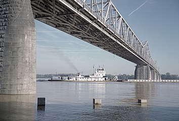
One of the two largest openings in the bridge ( span 250 meters) under one of the suspension girders
Junction of the two Gerber girders above the central river pillar

Access to the bridge on the Louisville side

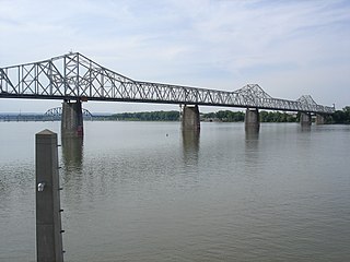
The George Rogers Clark Memorial Bridge and on the right the bridges following the river in 2006

Indiana driveway pylon


The superstructure of the main bridge rests on eight bridge piers, most of which were lowered to the bedrock of the river bed by means of caissons (with areas of up to 24 m × 9 m) (maximum depth 20 m). Since the rock layer on the Kentucky shore drops sharply, the first pillar that is not in the river bed rests here at a depth of about 12 m on a layer of sand and gravel. The pillars are made of sandstone and have a concrete core, with the edge stones of the river piers being largely made of granite as protection against ice drift . The river pillars rise about 19 m at normal water level, the clear height below the superstructure is 22 m. The driveways are mainly supported by steel masts, the sandstone bases of which are anchored in the ground by concrete pile foundations .
literature
- Ralph Modjeski, Frank M. Masters: The Louisville municipal bridge over the Ohio river between Louisville, Kentucky and Jeffersonville, Indiana. Modjeski & Masters, Consulting Engineers, Harrisburg 1930, ( digitized ).
- Holly B. Higgins: Historic Documentation of the George Rogers Clark Memorial Bridge in Jeffersonville, Clark County, Indiana. Contract Publication Series 13-251, Cultural Resource Analysts, 2013 ( PDF ).
Web links
- Louisville Municipal Bridge Construction. The Filson Historical Society, Image Database.
Individual evidence
- ^ Louisville Municipal Bridge, Pylons and Administration Building. NPGallery Digital Asset Management System, National Park Service. Retrieved March 10, 2019.
- ^ John E. Kleber: The Encyclopedia of Louisville. University Press of Kentucky, Lexington 2015, ISBN 978-0-8131-2100-0 , pp. 460 f.
- ^ John E. Kleber: The Encyclopedia of Louisville. University Press of Kentucky, Lexington 2015, ISBN 978-0-8131-2100-0 , p. 89.
- ^ A b Ralph Modjeski, Frank M. Masters: The Louisville municipal bridge over the Ohio river between Louisville, Kentucky and Jeffersonville, Indiana. Modjeski & Masters, Consulting Engineers, Harrisburg 1930, pp. 5-7.
- ↑ Martha Elson: Tolls nothing new here, but don't expect booths. Courier Journal, March 19, 2016. Retrieved March 11, 2011.
- ↑ Michael L. Jones: Clark Memorial Bridge painting and repairs lead to grid lock, safety concerns. Insider Louisville, May 18, 2018. Retrieved March 9, 2019.
- ^ A b Holly B. Higgins: Historic Documentation of the George Rogers Clark Memorial Bridge in Jeffersonville, Clark County, Indiana. Contract Publication Series 13-251, Cultural Resource Analysts, 2013 (Appendix E. Measured Drawings).
- ^ A b Ralph Modjeski, Frank M. Masters: The Louisville municipal bridge over the Ohio river between Louisville, Kentucky and Jeffersonville, Indiana. Modjeski & Masters, Consulting Engineers, Harrisburg 1930, pp. 7-24.