
Gfieder
| Gfieder | ||
|---|---|---|
 |
||
| height | 609 m above sea level A. | |
| location | Southern Lower Austria | |
| Mountains | Rax Schneeberg Group | |
| Dominance | 2.5 km → Kohlberg | |
| Notch height | 85 m ↓ north of Vöstenhof | |
| Coordinates | 47 ° 42 '55 " N , 16 ° 0' 33" E | |
|
||
| rock | Phyllite and Rohrbacher conglomerate | |
| Normal way | Hike | |
| particularities | Lookout point | |

The Gfieder is a 609 m high mountain in southern Lower Austria . It is located in the municipality of Ternitz and is known for the Gfiederwarte and the Vierbrüderbaum, protected as a natural monument ( list entry ) .
The Gfieder rises as a local mountain west of the city, it is the spur peak at the confluence of the Sierning in the Schwarza .
A lookout tower was first built at Gfieder in 1887. In 1988 a 14 m high control room was built and in 2004 it was replaced by a new one owned by the Austrian Tourist Club - Ternitz Section. The view extends to Lake Neusiedl .
To the west of the Gfieders, already in the community of Bürg-Vöstenhof , is the four-brother tree, a black pine that dates from 980 and grew up in four trunks when it was bitten by wild animals . Placed under nature protection in 1930, damaged by the effects of war from 1939 to 1945. In 1972 lightning struck two of the trunks and set the tree on fire. Two logs are charred and dropped. So today the tree only consists of two trunks.

Gfiederwarte
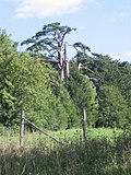
Four brothers tree

Four brothers tree

.jpg)

Web links
Individual evidence
- ^ ÖTK: Gfieder-Warte. April 10, 2017. Retrieved February 22, 2018 .
- ↑ Board by the four brothers tree