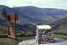
Glen Roy
Glen Roy is a valley in the Scottish Highlands now classified as a National Nature Reserve . It is particularly known for the geological phenomenon of parallel roads ("Parallel Roads").
Location and access
Glen Roy is a northern tributary valley of Glen Spean , about 25 km northeast of Fort William . The river Roy flows in the Glen Roy, which flows into the river Spean at the end of the valley. There is the village of Roybridge with its own train station on the West Highland railway line. A narrow single-lane driveway branches off the British national road A86 into the valley, which reaches Brae Roy Lodge after 15 km.
Phenomenon of parallel streets
On the slopes of the valley you can see three parallel lines at 260 m , 325 m and 350 m , which from a distance look like roads, hence their name.
In fact, there are three approx. 10 m narrow terraces that show the shorelines of a former lake. It was formed around 13,000 years ago during a brief cooling of the climate that lasted only 900 to 1100 years. At that time, glacier ice was advancing from the west and blocking the natural flow of water through the Glen Spean. A lake built up here and in the side valleys, the water level of which rose until it finally reached a threshold at 260 m over which the water could flow northeast into the Strath Spey . As the ice barrier advanced further, the arm that extended into Glen Roy was separated from the lake in Glen Spean, so that the water there continued to rise until it found a new drain to the south at 325 m . With a further advance of the glacier front this drainage was also blocked and the lake, which finally rose to 350 m, emptied to the north. When the glacier ice later retreated, the opposite development occurred, so that the lake first returned to the middle, then the lower level, before finally disappearing completely. As the lake level remained at the same level for several hundreds of years, the narrow terraces on the valley slopes, which are now visible as parallel roads , formed on the bank due to wave erosion and freezing and thawing processes of the lake ice.
Today, the parallel streets are no longer completely horizontal, but rise slightly to the northwest (gradient of 11 to 14 cm per km). This can be explained by the slightly uneven uplift of the local land mass when the former ice sheet melted.
History of geological decoding
Originally, the parallel streets were thought to be the enigmatic work of fairies or the hunting trails of the Celtic warrior Fingal . In the late 18th century it was still believed that the terraces were laid out for hunting: once narrow aisles were cut in the forest and the ground was leveled there; Frightened game is said to have been lured onto the parallel streets, on the edge of which archers hid in the forest to kill the prey.
In the 19th century, the strange lines became a much discussed topic in the fledgling geology . Among the scholars who studied it were Reverend William Buckland , James Geikie , Joseph Prestwich , Charles Lyell, and Charles Darwin . During his visit in June 1838, he realized that the lines indicated the course of the former sea coast. In 1840, Louis Agassiz , one of the last great zoologists to oppose Darwin's theory of evolution, contradicted him with the glacial theory that is still recognized today as valid. It was not until about 40 years later, shortly before his death, that Darwin publicly admitted that he had been wrong about his theory about the parallel streets. As early as 1861, however, he wrote in a letter: “I am devastated about Glen Roy. My scientific publication was one huge gross mistake from start to finish. "
The parallel streets are still very popular with scientists, who are fascinated by the dramatic processes that have shaped the landscape, and tourists who are drawn to the natural wonder.
Individual evidence
- ↑ Men of Rock Preview: The Mystery of Glen Roy's Parallel Roads , BBC Two Video, 2011
- ^ John Tyndall: Fragments of Science , (1905), Chapter VIII (Eng.)
- ↑ (Engl.) Letter from CR Darwin to Charles Lyell from September 6, 1861 ( Memento of the original dated 2 September 2007 at the Internet Archive ) Info: The archive link is automatically inserted and not yet tested. Please check the original and archive link according to the instructions and then remove this notice.
- ^ "Observations on the Parallel Roads of Glen Roy, and of other parts of Lochaber in Scotland, with an attempt to prove that they are of marine origin. By Charles Darwin, Esq., MAFRS Sec. GS (1839) "(Engl.)
Web links
Coordinates: 56 ° 55 ′ 47.5 " N , 4 ° 47 ′ 45.4" W.


