Gmundnerberg
| Gmundnerberg | ||
|---|---|---|
|
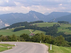
View from the Gmundnerberg to the Grasberg |
||
| height | 884 m above sea level A. | |
| location | Upper Austria , Austria | |
| Mountains | Traun and Atterse Flysch Mountains , Salzkammergut Mountains | |
| Dominance | 3.1 km → high air | |
| Notch height | 309 m ↓ Örach | |
| Coordinates | 47 ° 54 '30 " N , 13 ° 43' 40" E | |
|
|
||
| rock | Flysch main ceiling | |
| Development | Gmundnerbergstrasse (1937) | |
The Gmundnerberg is 884 m above sea level. A. high mountain in the market town of Altmünster , Gmunden district .
General
The Gmundnerberg is one of the most famous panoramic mountains in Upper Austria, as almost the entire Traunsee basin with the rocky elevations of the east bank (Traunstein, Erlakogel, Gasslkogel), the western peaks of the Dead Mountains , almost the entire Höllengebirge and the wooded mountains of the Flysch region ( Richtberg, Hongar, Kollmannsberg etc.) can overlook. The tourist rush feeds a large number of gastronomic businesses that have settled along the Bergstrasse. Several streets run along the ridge that lead to private houses and are often used as hiking trails because of their rewarding views.
The ridge of the Gmundnerberg lies diagonally from southwest to northeast between the Aurach , which flows in a bend in the valley from Reindlmühl to Pinsdorf , the meadow-rich Grasberg (746 m) and the outskirts of Altmünster (Eck), Gmunden (train station) and Pinsdorf . About three quarters of the massif are located in the municipality of Altmünster, the northeastern foothills, however, belong to Pinsdorf, whose appearance it has a major influence on. This part, officially called Pinsdorfberg , is heavily forested and accessed by an asphalt forest road, which then merges into Gmundnerbergstraße. On the Pinsdorfberg there is a marl quarry that serves as a raw material supplier for the cement works in the Gmunden train station area, which belongs to the Rohrdorfer Group and is located directly below the extraction site.
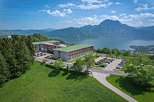
On the Gmundnerberg plateau there is a chapel, an observatory and excursion inns as well as parking spaces as well as a neurological therapy center, which belongs to the Vamed group and was opened in 2010. It is located on the site of a pulmonary hospital that had been vacant for years. The Gmundnerberg is heavily sprawled, still managed and former farmsteads as well as modern houses alternate and reach in the southwest down to the lowlands of the Aurach valley.
geography
The landscape around the Traunsee has three different characters. In the south are the rugged, high mountains of the Limestone Alps with the Traunstein . Further north, at the extension of the Traunsee basin, the densely wooded ridges of the Flysch Mountains join without rock walls and steep steps. This is followed by the gently rolling foothills of the Alps , in which the city of Gmunden is located in the opening of the Traunsee basin .
Gmundnerbergstrasse
The Gmundnerbergstraße (L1301) branches off the state road (L1299) leading from Altmünster to Reindlmühl at the hamlet of Edt in a northerly direction and after a short straight section winds westwards up the mountain before it runs eastwards after a hairpin before reaching the plateau. To the east of the Gmundnerberg chapel, its use is only open to residents. From then on it crosses the entire ridge and at the level of the marl quarry goes seamlessly into the Pinsdorfbergstrasse, which is only accessible to a limited extent.
In 1933 construction work began on the road to Gmundnerberg. The "productive unemployment welfare" funded the construction. The neighbors provided the required floor space (with one exception) free of charge. The dimensions of the street were dimensioned in such a way that both residents and tourists could use the street without any problems.
The Altmünster community, which began construction in November 1933 with 92 unemployed people, also received funding to build a road from Edt over Grasberg to Neukirchen. The northern end of Grasbergstraße joins the L1299 at the same point where Gmundnerbergstraße begins.
At the end of 1937 the road to the “Zur Luft” inn was completed except for the fine gravel.


