Gohlis (Zeithain)
|
Gohlis
Zeithain parish
Coordinates: 51 ° 20 ′ 47 ″ N , 13 ° 17 ′ 24 ″ E
|
||
|---|---|---|
| Area : | 4.91 km² | |
| Residents : | 470 (December 31, 2014) | |
| Population density : | 96 inhabitants / km² | |
| Incorporation : | January 1, 1999 | |
| Postal code : | 01619 | |
| Area code : | 03525 | |
|
Location of Gohlis in Saxony |
||
Gohlis is a right side of the Elbe situated district of the Saxon community Zeithain in the district of Meissen .
geography
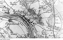
The place is located directly on the Elbe between the places Bobersen and Zschepa on the Elbe Cycle Path, about 4.7 km southeast of Strehla . Across from Gohlis on the other bank of the Elbe lies the Forberge district, which belongs to Strehla. The place was originally a line village with a corridor of 491 hectares.
history
The place was first mentioned in 1186. The name Gohlis is of Wendish origin and means heath place. The place name was changed several times, for example Gohlis was called Goliz in 1160, Goliz in 1234, Goliz in 1299, Golicz in 1409 and Goliß or Golis in 1539. It was not until 1875 that the current spelling of the place name prevailed. The place is said to have originated from an Elbe ferry. The ferry house was probably later supplemented by a hostel and fishermen's huts. Gohlis is of Slavic origin. It is believed that the place was founded in the 5th century, when the Wends settled in the area after the Hermundures.
Before the Reformation, Gohlis was under Meissner jurisdiction and connected to the Hain monastery. In the middle of the 16th century there was a free inheritance court in Gohlis, the testator exercised the office of judge. He didn't have to pay interest, but kept an ox and a boar for the community. The Dingstuhl (court) was in Gohlis. The education authority held court every year. On this occasion, the residents were able to submit their complaints , which were negotiated.
In 1575 there was an inn in the village. The brewing vessel for brewing beer, the so-called brewing pan, belonged to the church. Both the owner of the Kretscham and the nobleman of the village of Schradewald, which was then part of the parish of Gohlis, had to pay interest to the church for every brewing process and a barrel can of beer (about 4 mugs) to the pastor and half to the schoolmaster. In 1595 the place is described as a small poor village with 16 hoofed and half-hoofed and 7 gardeners. The poverty was due to frequent floods and other natural disasters that threatened the place due to its location. There were major floods in 1746 and 1820. The place also suffered from conflagrations, for example in 1693, when on May 31st the whole village burned down except for 5 houses and the church. Important lands belonged to the place. Rye, barley, oats, millet, heather, peas, vetches, hemp and flax were grown, chickens and pigeons, sheep and cattle were raised and pigs were raised. Older field names still refer to the earlier viticulture, which was also operated in Gohlis. It was given up at the end of the 18th century because it was no longer worthwhile. In order to reduce the damage caused by natural disasters such as floods and forest fires, which often struck Gohlis, the Gohlis volunteer fire department was founded in 1895. In addition to the construction of a syringe house on the corner of Kirchstrasse and Lindenstrasse, the municipality acquired a hand-operated syringe together with the municipality of Lorenzkirch.
In 1823 the ferryman Johann Gottlieb Leidhold received a concession for the ferry between Oppitzsch and Gohlis. It was granted by the Landschulamt Meißen against payment of a canon of 5 thalers a year. From 1848 the municipality of Gohlis granted authorization to the owner of the ferry. In 1888 it was the grandson of ferry master Leidhold from Gohlis. In 1923 the ferry was no longer considered commercial.
School lessons were given early on in Gohlis. The first schoolhouse was built after 1575. It was demolished in 1854 because of dilapidation and replaced by a new building. The new building was inaugurated on September 24th of the same year by the pastor at the time. An expansion was necessary as early as 1890 due to the increasing number of students. The new extension was inaugurated on April 6, 1891. An additional assistant teacher took office on April 25, 1892. In 1901 2 teachers in 4 classes taught 195 school children. After the Second World War, the school combination Bobersen, Gohlis and Kreinitz was formed from the schools in the respective towns and was named after the young communist Fritz Schmenkel in 1975 .
The Saxon rural community order of 1838 gave Gohlis independence as a rural community. From 1843 Gohlis belonged to the Grossenhain office and from 1856 to the Strehla court office. From 1875 the village belonged to the Oschatz district administration. In 1896 the Gohlis residents lost a large part of their agricultural land. The land had to be forcibly sold to the Reich Military Treasury to expand the Zeithain training area. In 1925, 717 inhabitants of Gohlis were Evangelical Lutheran , 1 inhabitant was Catholic . 11 residents belonged to other denominations. In 1937 part of Zschepa (Kleinzschepa), which with its few houses borders directly on Gohlis, was incorporated. Saxony came to the Soviet occupation zone after the Second World War and later to the GDR. After the territorial reform in 1952, Gohlis was assigned to the Riesa district in the Dresden district.
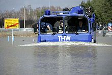
After reunification and reunification , Gohlis became part of the newly founded Free State of Saxony . Gohlis assigned the following regional reforms in Saxony in 1994 to the Riesa-Großenhain district and in 2008 to the Meißen district. In 1999 the place was incorporated into Zeithain. In the 21st century, the place was hit by several floods. During the flood of the century in 2002 , the place was flooded and had to be evacuated. Of 161 recorded properties, 44 were restricted and 26 houses were uninhabitable. After another flood in 2006 , at the urging of committed residents, the new 108 meter long flood bridge was built, which was opened on August 14, 2007. Gohlis was flooded again in 2013 , the damage to dykes, buildings and roads was again high.
Population development
The population has increased steadily since the Middle Ages and reached its maximum in 1950. Since then, the population has been falling again.
| year | Residents | year | Residents |
|---|---|---|---|
| 1551 | 18 possessed men , 8 residents, 22 hooves | 1933 | 1039 |
| 1764 | 15 possessed men, 10 cottagers , 22 hooves | 1939 | 1039 |
| 1834 | 403 | 1946 | 1032 |
| 1871 | 574 | 1950 | 1039 |
| 1890 | 673 | 1964 | 841 |
| 1910 | 732 | 1990 | 636 |
| 1925 | 1824 | 1999 | → Röderau-Bobersen |
Gohlis Church
The oldest building in Gohlis is the church. From the fabric of the building it can be concluded that it was built in the 2nd half of the 13th century or in the 1st half of the 14th century. It was first mentioned around 1250 as a branch church of Lorenzkirch. In 1575 the place or the Gut Schradewald of the owner Heinrich von Taupadel was parish after Gohlis, which was sold to the elector in 1595 and a little later became deserted. Heinrich von Taupadel owned the little prayer room on the gallery on the north side, from where the nobleman and his household attended the service. In 1756 the manor owner von Bobersen built a prayer room instead of the Taupadelschen. Today no other villages are parish. The middle bell from 1495 was a bronze monument. Major repairs were carried out in 1712 and 1773. Instead of a dilapidated wooden vestibule, in which the bells also hung, the tower-like bell house was built on the north side in 1822, which only slightly towers over the church. The church tower has been adorned by three new bells since September 10, 2007 (consecrated on August 26, 2007), which on September 26, 2007 for the first time sounded their voices far across the Gohliser corridor.
Personalities
- Ulf Kirsten (* 1965), former national soccer player
literature
- Cornelius Gurlitt : Gohlis. In: Descriptive representation of the older architectural and art monuments of the Kingdom of Saxony. 27. Booklet: Oschatz Official Authority (Part I) . CC Meinhold, Dresden 1905, p. 108.
- Saxony's church gallery. 7th volume. The Grossenhain, Radeberg and Bischofswerda inspections . Dresden 1840. Page 64 ( online. ), Accessed on January 23, 2015
- New Saxon Church Gallery Volume. Ephorie Oschatz . Leipzig 1901. Pages 187-200 ( online. ), Accessed on January 24, 2015
Web links
- Gohlis in the Digital Historical Directory of Saxony
- Gohlis on the website of the Zeithain community, accessed on January 23, 2015
Individual evidence
- ↑ Ferry Oppitzsch-Gohlis 112.0 km. In: Ferries and shipping on the Upper Elbe in Saxony and Bohemia. Klaus Stein, accessed on March 21, 2015 .
- ↑ Gohlis (Zeithain) in the Digital Historical Directory of Saxony
- ^ Michael Rademacher: German administrative history from the unification of the empire in 1871 to the reunification in 1990. Grossenhain district. (Online material for the dissertation, Osnabrück 2006).
- ↑ With the incorporation of Gohlis into Zeithain in 1999, only official population figures were collected for the entire community.


