
Goldbergsee Coburg
| Goldbergsee Coburg | |||||||||
|---|---|---|---|---|---|---|---|---|---|
 |
|||||||||
|
|||||||||
|
|||||||||
| Coordinates | 50 ° 17 '5 " N , 10 ° 56' 29" E | ||||||||
| Data on the structure | |||||||||
| Data on the reservoir | |||||||||
| Reservoir length | 2 km | ||||||||
| Reservoir width | 380 m | ||||||||

The Goldbergsee Coburg on the edge of the Coburg districts of Neuses and Beiersdorf is a reservoir of 145 hectares , which was designed as a flood retention basin and is included in the overall flood protection concept for Coburg and the Itzgrund . Preliminary work had already started in 2003, construction started in 2006. The damming followed from the end of 2010.


Project
When large areas of continuous rain and snowmelt at high altitudes of the Thuringian Forest come together , winter floods often occur in the Itz river basin , which lead to flooding in the city of Coburg and the Itzgrund to the south. The complex interaction of the Itz tributaries Röden and Lauter and in turn their tributaries Sulzbach and Rottenbach has been countered with an extensive flood protection concept since the 1980s. Coburg, in whose inner city area Itz and Lauter converge, represents a bottleneck for the outflowing water. To prevent flooding, the flood has to be held back in front of the city.
The Froschgrundsee retention basin has been in operation on the upper Itz since 1986 . The Goldbergsee Coburg flood retention basin above Coburg-Neuses primarily dams the Sulzbach. In addition, the floods from the Lautertal, which amount to more than 4 m³ / s, are transferred via a gravity tunnel with a gradient of 0.771% and a flood basin into the Goldbergsee if necessary . These technical measures are supplemented by ecological remodeling of the rivers mentioned. This also naturally delays flood runoff.
The water areas of the Goldbergsee Coburg are divided into three different areas: the Grundsee, the biotope lake and the flood basin for the Lauterüberleitung. Between Grundsee and biotope the railway line crosses Coburg - Bad Rodach in embankment terrain. To the north of the biotope lake with a shallow water zone and an extensive stock of reeds is the nature reserve Vogelfreistätte Glender Wiesen . In autumn the Grundsee is lowered by up to two meters in order to gain additional flood retention space. The biotope lake is only lowered by half a meter to protect the vegetation.
Technical specifications
The Goldbergsee Coburg has a water surface of around 71.5 hectares in summer , in winter it is 31.3 hectares in size. In the event of flooding, up to 145 hectares can be dammed. The entire catchment area covers 52 square kilometers. The height of the dam structure is 7.0 meters above the valley floor, the crown length is 290 meters. The total storage space is given as 4.0 million cubic meters and around 2.0 million cubic meters as the flood retention area. The total cost of building the project was 29.5 million euros. This also includes the cost of raising the 2205 state road between the Coburg districts of Neuses and Beiersdorf.
The passage of the high water of the Lauter, which is designed for a maximum of 17.5 m³ / s, is 4250 meters long. It consists of a 1500 meter long flood channel, an 800 meter long free flow section along the Kleinbach ditch and a 1945 meter transfer tunnel. The gravity tunnel has an internal diameter of three and a half meters and a clear cross-sectional area of 8.44 square meters. It was mined over a length of 1750 meters. The contract for the construction of the tunnel and hydraulic structures in the inlet and outlet area was awarded in August 2009 for around 20 million euros, on November 10, 2009 the official tunnel was opened at Beuerfeld and on February 16, 2011 the tunnel breakthrough in Oberlauter . Construction work was completed by the end of 2012. In 2003, the Bavarian State Ministry for the Environment, Health and Consumer Protection assumed costs of 12 million euros; the Kronach Water Management Office originally estimated the total contract value at 16 million euros. The total costs of the reconciliation were estimated at 20.8 million euros and have increased to 25.3 million euros. On December 23, 2012, water flowed from the Lauter through a tunnel into the Goldbergsee for the first time.
Pictures of building history and structures

Old and new Sulzbach Bridge, August 2007

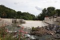
Finished dam and new stream bed, August 2007

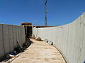
Gate valve house under construction, August 2007
Fish ladder, August 2007

Outlet structure
Inlet structure of the transfer tunnel

Inlet structure of the transfer tunnel during flooding

Outlet structure of the transfer tunnel in case of flooding


See also
Web links
- Project description on the website of the Kronach Water Management Authority
- Goldbergsee lake level at the Bavarian flood news service
Individual evidence
- ↑ Coburg Official Gazette No. 19
- ↑ Article in the journal Die Flussmeister , 2010 edition, page 15 ff. PDF, accessed on January 23, 2011
- ↑ a b Announcement about awarded contracts, September 3, 2009 ( Memento of the original from January 22, 2015 in the Internet Archive ) Info: The archive link was inserted automatically and has not yet been checked. Please check the original and archive link according to the instructions and then remove this notice.
- ↑ Bavarian State Ministry for the Environment, Health and Consumer Protection: Press release No. 176/03, May 12, 2003 ( page no longer available , search in web archives ) Info: The link was automatically marked as defective. Please check the link according to the instructions and then remove this notice.
- ^ Coburger Tageblatt, November 23, 2012, p. 8
- ↑ Neue Presse, February 5, 2013