
Gulf of Orosei
| Gulf of Orosei | ||
|---|---|---|
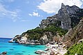
 View of the Gulf of Orosei near the town of Orosei |
||
| Waters | ||
| Geographical location | 40 ° 18 ′ N , 9 ° 41 ′ E | |
|
||
| width | approx. 30 km | |
| depth | approx. 10 km | |

The Gulf of Orosei ( Italian Golfo di Orosei ) is a bay that extends over an approximately 30 km long indentation on the east coast of Sardinia . The coastal area is characterized by the foothills of the Supramonte mountain range , the slopes of which drop several hundred meters perpendicular to the sea.
Many beaches in small bays, which are often only accessible from the sea or via a hike from the plateau, such as B. Cala Cartoe , Cala Fiuli , Cala Luna , Cala Sisine , Cala Biriola , Cala Mariolu and Cala Goloritzè make the Gulf of Orosei a popular tourist destination. Further sights are the stalactite caves Grotta del Bue Marino and Grotta del Fico . From Santa Maria Navarrese and Cala Gonone , day cruises are offered along the cliffs that visit these places.
The town of Orosei with about 6300 inhabitants is located three kilometers from the coast of the Gulf of Orosei. Neighboring communities are Dorgali , Galtellì , Onifai and Siniscola .
The National Park of Gennargentu and the Gulf of Orosei includes both mountain and coastal zones and has a total area of 73,935 hectares.
literature
- Eberhard Fohrer: Sardinia . 10th edition, Erlangen: Michael Müller Verlag 2006 ISBN 978-3-89953-369-9
Web links
photos
Cala Goloritzè on the Gulf of Orosei

Entrance to the Grotte del Bue Marino
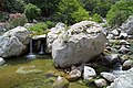
Codula di Luna; a river that flows into the famous Cala Luna beach


