Grafing (Sauerlach)
|
Grafing
Municipality Sauerlach
Coordinates: 47 ° 57 ′ 10 " N , 11 ° 38 ′ 40" E
|
|
|---|---|
| Residents : | 147 (2019) |
| Postal code : | 82054 |
| Area code : | 08104 |
|
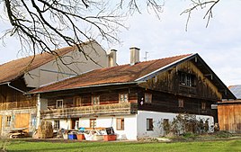
Living part of the Hakenhof, so-called Beim Gastl
|
|
Grafing is a district of the Upper Bavarian community Sauerlach in the district of Munich . The settlement is located south of the main town and north of Lochhofen and currently has 157 inhabitants (as of 2019).
Infrastructure
Today's State Road 2573 (formerly Bundesstraße 13) runs east of the outskirts. The bus line 223 connects Grafing, Lochhofen and Arget with the main town Sauerlach and thus with the Munich S-Bahn .
| line | course |
|---|---|
| 223 | Sauerlach (train station) - Sauerlach, Martinstraße - Grafing - Lochhofen, Bavariastraße - Lochhofen, Michelistraße - Arget, Finkenweg - Arget, Oberhamer Straße - Arget, Holzkirchner Straße - Lochhofen, Abzw. - Grafing, Neubauerweg - Sauerlach, Martinstraße - Sauerlach (train station) , Sauerlach, School - Sauerlach, Ludwig-Bölkow-Strasse - Sauerlach, Robert-Bosch-Strasse - Sauerlach, Mühlweg |
Individual evidence

