Grama Bay
| Grama Bay Gjiri i Gramës |
||
|---|---|---|
|
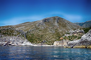
View from the north into the bay |
||
| Waters | Ionian sea | |
| Land mass | Albania | |
| Geographical location | 40 ° 12 '56 " N , 19 ° 28' 24" E | |
|
|
||
| width | approx. 100 m | |
| depth | approx. 200 m | |
| Tributaries | Grama-Bach (also Bach of St. Anthony ; not always water-bearing) | |
|
View from the sea to the bay |
||
The Grama Bay ( Albanian Gjiri i Gramës ) is a small bay on the Albanian coast of the Ionian Sea . It is one of several bays on the west side of the Akroceraunian Mountains south of the Karaburun peninsula.
location
The bay cuts about 200 meters deep into the coastline. Towards the sea, the shore is characterized by rock walls that drop vertically into the water. At the end of the bay, however, there is a shallow beach. This is where the valley of the Grama Brook ( Albanian Përroi i Gramës ; also Bach of St. Anthony ) begins .
The area around Grama Bay is not populated. It is located on the Albanian Riviera about 14 kilometers northwest of Dhërmi and 12.5 kilometers south of Orikum and 25 kilometers south of Vlora . The barren, stony region has not been developed. The next road is more than six kilometers as the crow flies in the north-west beyond the Akroceraunischen Mountains, here called Rrëza e Kanalit in the Maja e Valit an altitude of 1362 m above sea level. A. achieved. Guidebooks do not recommend walking to the bay.
History and inscriptions
Since the 6th century BC The bay served as a quarry for limestone , which was used in constructions in Apollonia , Oricum and Durrës . The steep cliffs are from these activities; another mining site was around 100 meters inland. Drinking water was collected in hollowed-out stone basins.
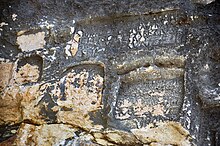
In the past, ships repeatedly sought shelter from bad weather in the bay. It is one of the few places along the coast that is suitable for mooring. The seafarers and the quarry workers left around 1500 inscriptions on the rock walls of the bay . The oldest, written in Greek , date from the 3rd to the 1st century BC. BC, the youngest from the 20th century. For a time, was the Latin used, but mostly Greek. In the early days and in the Middle Ages it was mostly about requests and thanks to the gods, in Roman and later times mostly about notes of presence. An inscription comes from Emperor Johannes V and is dated 1369. Some of the inscriptions can be found under the - today's - waterline, and some up to a height of four meters. They are seldom supplemented with simple drawings.
Chapels were set up in two caves . Its walls are also decorated with inscriptions.
The name of the bay is derived from the Greek γράμμα, which means written or letter . The Grammata inscriptions were first described by Cyriacus of Ancona in 1435. The Austrian archaeologist Carl Patsch published copies of the inscriptions. In 1930 Luigi Ugolini visited the bay.
The bay with the caves and an underwater cave has been declared a natural monument. Grama Bay is part of the Karaburun-Sazan Marine National Park . The inscriptions are protected as a national cultural monument under the name “Inscriptions on the Gramata Rock” .
Web links
Individual evidence
- ↑ Official map 1: 50,000 of the military cartographic office of Albania, sheet K-34-135-B, Tirana 1982
- ↑ a b c d Ylber Hysi: Southern Albanian Riviere Vlora – Saranda . Gent Grafik, Tirana 2010, ISBN 978-99956-51-11-4 , The bay of Grama (Gramata), p. 55-57 .
- ↑ Oliver Gilkes: Albania: An Archaeological Guide . IB Tauris, London 2013, ISBN 978-1-78076-069-8 , Grama Bay, pp. 203 .
- ↑ a b c Bashkim Lahi: Grammata . In: Christian Zindel, Andreas Lippert, Bashkim Lahi, Machiel Kiel (eds.): Albania: an archeology and art guide from the Stone Age to the 19th century . Böhlau, Vienna 2018, ISBN 978-3-205-20723-8 , pp. 133-135 .
- ↑ Gjiri dhe shpella s grief. Agjencia Kombëtare e Zonave të Mbrojtura (AKZM), August 9, 2005, accessed on June 9, 2018 (Albanian).
-
↑ Parku Kombëtar Detar "Karaburun-Sazan". Agjencia Kombëtare e Zonave të Mbrojtura (AKZM), accessed on June 9, 2018 (Albanian). Karaburun-Sazan Marine National Park. National Agency of Protected Areas AKZM, accessed on July 12, 2018 .
- ↑ List e monumenteve të Kulturës - Qarku Vlorë 2017. (pdf, 318 kB) Instituti i Monumenteve të Kulturës, December 29, 2017, p. 11 , accessed on June 9, 2018 (Albanian).


