
Grand Coulee Bridge
Coordinates: 47 ° 57 ′ 56 " N , 118 ° 58 ′ 56" W.
| Grand Coulee Bridge | ||
|---|---|---|
 |
||
| use |
|
|
| Crossing of | Columbia River | |
| place | Coulee Dam and Grand Coulee , Washington | |
| Entertained by | Washington State Department of Transportation (WSDOT) | |
| construction | Gerber girder - truss bridge | |
| overall length | 325 m | |
| Longest span | 168 m | |
| start of building | 1934 | |
| completion | 1936 | |
| planner | George Stevens (Washington Department of Highways) | |
| location | ||
|
||
 |
||

The Grand Coulee Bridge is a two-lane road bridge over the Columbia River in Coulee Dam , Washington . It leads Washington State Route 155 about a kilometer downstream behind the Grand Coulee Dam over the underwater of the barrage . The Gerberträger - truss bridge was built by the Bureau of Reclamation in the course of the construction of the dam in 1935 and, until its completion in 1942, was also used to transport heavy construction machinery and material, for which it was designed for higher loads than usual. The bridge has been under the administration of the Washington State Department of Transportation since 1959 and was placed on the National Register of Historic Places in 1982 .
history
As part of the Columbia Basin Project , the dam of the same name on the Columbia River was built from 1933 at the northern end of the Grand Coulee . In addition to temporary bridges for the construction project, the Bureau of Reclamation planned a road bridge to connect the settlements built on both sides of the river for the construction workers, from which the village of Coulee Dam emerged . In order to be able to use it to transport heavy construction machinery and materials during the construction project, it was designed for higher loads than is usual for road bridges. The design comes from George Stevens of the then Washington Department of Highways . Construction work on the bridge piers began in 1934 by the Western Construction Company of Spokane and the steel superstructure was built by the JH Pomeroy Company of San Francisco by the fall of 1935 ; the first concrete for the dam was poured in December 1935. Shortly before the superstructure was completed, a slight tilting of the eastern pier towards the middle of the river was noticed. Movements on the eastern slope slowly pushed the reinforced concrete pillar built on the rock out of its original position. With the help of a round coffer dam almost 34 meters in diameter, the soil around the pillar was excavated to a depth of 24 meters and further concentric ring dams were installed within it for stabilization. The pillar then erected itself again on its own. To reinforce the foundation, the excavated area is later filled with concrete. Before the work was completed, the bridge was opened to traffic on January 27, 1936 with a temporary securing of the steel girder.
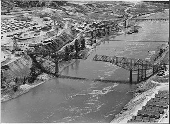
Assembly of the tanner girder in August 1935 (view upstream)
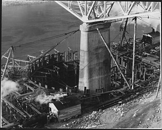
Coffer dam to strengthen the foundations of the east pillar in January 1936
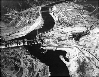
Construction progress on the dam wall in 1938, behind it the Grand Coulee Bridge (view downstream)


After the Grand Coulee Dam, one of several other barrages was built 82 kilometers upriver with the Chief Joseph Dam on the Columbia River, which has dammed Rufus Woods Lake since the mid-1950s and also raised the water level under the Grand Coulee Bridge. In 1959 the bridge was handed over to the Washington Department of Highways , which was renamed the Washington State Department of Transportation (WSDOT) in 1964 . It leads the Washington State Route 155 , which runs north to south between Omak and Coulee City, over the underwater of the Grand Coulee Dam in what is now the town of Coulee Dam and in 2016 had a daily traffic volume of almost 5,000 vehicles. In July 1982, the bridge was added to the National Register of Historic Places (NRHP # 82004267).
description
The central element of the Grand Coulee Bridge is a symmetrical steel tanner girder with a total length of 290 m. It is divided into two lattice girders on the two river pillars, each forming a 61 m long anchor arm (AA) towards the bank and a 53 m long arm (CA) towards the middle of the river. In between, a 61 m long, parallel- belted truss suspension beam (SS) is articulated, creating a 168 m wide main opening between the central pillars. Including a few short beam girders for the driveways, the bridge has a total length of over 300 m; the exact details vary between 325 m and 332 m.
The tannery girder has a straight upper chord which is only slightly inclined at the ends and to which the roadway runs parallel at the level of the lower chord of the suspension girder. In relation to the pillar supports, the height of the outer truss increases to more than double the height of the suspension girder, creating a characteristic triangular shape below the roadway. The Washington Department of Highways chose a similar design for the Deception Pass Bridge (1935) and Kettle Falls Bridge (1941), where the roadway runs on the upper chord and the curvature of the lower chord is continued on the suspension beam.
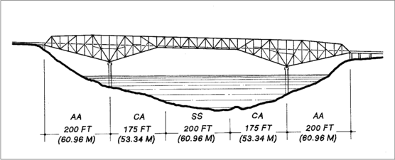
Simplified schematic drawing of the tanner bearer
(view upstream, left the east side)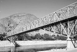
The truss bridge in 1993 (view to the northwest)

_Grand_Coulee_Bridge.png)

The two large river pillars were erected directly on the bedrock of the canyon at the Grand Coulee Bridge and reach a height of 46 m, measured from the lower edge of the foundation. The 18 m high rectangular foundations have (or had) areas of 8.2 m × 17.7 m, the east pillar this was expanded accordingly for stabilization. On the foundations are the 28 m high oval pillars visible in the upper area, on which the approximately seven meter wide tanner girders rests. With normal water level of the underwater of the barrage, the clear height below the lower flange of the suspension beam is about nine meters. The carriageway has a width of 6.1 m between the curbs and offers space for two lanes. On the outside of the truss, there is a 1.5 m wide footpath with a railing attached to additional brackets on both sides. Since the eastern edge of the canyon is about ten meters higher than the opposite side, the bridge including the roadway has a slight gradient to the west.
See also
literature
- Lisa Soderberg: Grand Coulee Bridge. HAER / Washington State Bridge Inventory, Washington, DC 1979.
- Robert W. Hadlow: Columbia River Bridge at Grand Coulee Dam. Historic American Engineering Record, HAER No. WA-102, Washington, DC 1993.
Web links
- Grand Coulee Bridge. HistoricBridges.org
- Columbia River Bridge at Grand Coulee Dam, spanning Columbia River at State Route 155, Coulee Dam, Okanogan County, WA. HAER No. WA-102, Library of Congress.
Individual evidence
- ↑ a b c Robert W. Hadlow: Columbia River Bridge at Grand Coulee Dam. Historic American Engineering Record, HAER No. WA-102, Washington, DC 1993.
- ^ Grand Coulee Bridge. BridgeHunter.com, accessed May 27, 2020.
- ^ Lisa Soderberg: Grand Coulee Bridge. HAER / Washington State Bridge Inventory, Washington, DC 1979.
- ^ Grand Coulee Bridge. HistoricBridges.org, accessed May 27, 2020.
- ^ Robert W. Hadlow: Washington State Cantilever Bridges, Olympia, Thurston County, WA. Historic American Engineering Record, HAER No. WA-106, Washington, DC 1993.
- ↑ 47.96536, -118.98236. CalTopo Backcountry Mapping, accessed May 28, 2020.