
Kettle Falls Bridge
Coordinates: 48 ° 37 ′ 33 " N , 118 ° 7 ′ 4" W.
| Kettle Falls Bridge | ||
|---|---|---|
.jpg) |
||
| use |
|
|
| Crossing of | Columbia River | |
| place | Kettle Falls , Washington | |
| Entertained by | Washington State Department of Transportation (WSDOT) | |
| construction | Gerber girder - truss bridge | |
| overall length | 386 m | |
| Longest span | 183 m | |
| completion | 1941 | |
| location | ||
|
||
_location_map.svg)
The Kettle Falls Bridge is a two-lane road bridge over the Columbia River , which is dammed here to Franklin Delano Roosevelt Lake . It lies at the eastern end of the 240 kilometer-long dam, about five kilometers northwest of Kettle Falls , Washington and leads the US Highway 395 and Washington State Route 20. The Gerber beam - truss bridge was until 1941 during the construction of the Grand-Coulee- Dam built together with the parallel Kettle Falls Railroad Bridge by the Bureau of Reclamation and replaced a road bridge from 1929 that was too low for the reservoir. The bridge is under the administration of the Washington State Department of Transportation and was included in the National Register of 1995 Historic Places listed.
history
The Kettle Falls Bridge |

With the expansion of the road network in Washington State in the 1910s, a north-south connection was established in the eastern section with the Inland Empire Highway from the Canadian border at Laurier via Spokane to Kennewick - a parallel route led from Spokane to Walla Walla - and further west to Yakima . At that time the roads were mainly gravel roads and the river crossings were realized by car ferries . Asphalting began in the 1920s and the first road bridges were built, for example the Pasco – Kennewick Bridge (1922) over the lower reaches of the Columbia. In the northern part of 1923 at State Road No. 3 renamed expressway had to be crossed on the way from Colville to the Canadian border of the upper reaches of the Columbia, where in 1929 a first 372 meter long truss steel bridge was built not far from the rapids Kettle Falls .
As part of the Columbia Basin Project , the dam of the same name was built on the Columbia River at the northern end of the Grand Coulee from 1933, which was to dam the upper reaches of the Columbia River and parts of the Spokane River to the 240-kilometer-long Franklin Delano Roosevelt Lake and its northern part as well the Kettle Falls and the local road bridge would flood. Since the laying of several railway lines became necessary, the Bureau of Reclamation planned a new combined railway and road bridge at Kettle Falls. However, since no agreement on the conditions of use could be reached with the Great Northern Railway , it was decided to build two separate parallel bridges, which were built upstream right next to the old road bridge by 1941. The bridge from 1929 was torn down before the reservoir rose.
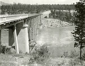
With the introduction of the United States Numbered Highway System , the Kettle Falls Bridge became part of US Highway 395 , which covers large parts of State Road No. 3 and largely follows the course of the former Inland Empire Highway in Washington - from Spokane on the western route via Ritzville to Kennewick - and today extends to California to the Mojave Desert . The construction of a third run-of-river power station at the Grand Coulee Dam made it necessary to reduce the reservoir in the spring of 1966–1974, which led to the partial exposure of the former rapids that were visible again above the bridges. In 1995 the bridge was inscribed on the National Register of Historic Places (NRHP # 95000260).
The first 1929 road bridge at Kettle Falls (1938 photo)
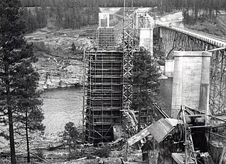
Construction of the new bridge piers in 1940 up to the level of the old street level (view to the east)
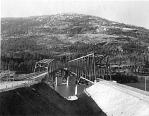
The completed bridges at the end of 1941, old ones removed (road bridge on the left, view to the west)

Partly Uncovering the Kettle Falls during the expansion of the Grand Coulee Dam in the spring of 1969

.jpg)


description
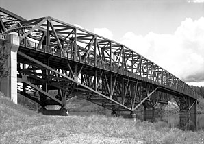
The central element of the Grand Coulee Bridge is a symmetrical steel tanner girder with a total length of 320 m. It is divided into two lattice girders on the two river piers, which each form a 69 m long anchor arm (AA) towards the bank and a 46 m long arm (CA) towards the middle of the river. In between, a 91 m long, parallel- chorded truss suspension beam (SS) is articulated, creating a 183 m wide main opening between the central pillars. Including a few short beam girders for the approaches, the bridge has a total length of 386 m.


The tannery girder has a straight upper chord which is only slightly inclined at the ends and to which the roadway runs parallel at the level of the lower chord of the suspension girder. In relation to the pillar supports, the height of the outer lattice girders increases to about twice the height of the suspension girders, creating a characteristic triangular shape below the roadway. The Washington Department of Highways chose a similar design for the Deception Pass Bridge (1935) and Grand Coulee Bridge (1936), where the roadway runs on the upper chord and the curvature of the lower chord is continued on the suspension beam.
West side of the steel beam, 1993

Simplified schematic drawing of the tanner bearer
(view downstream, left the east side)
East portal, on the right the railway bridge
.jpg)
_Kettle_Falls_Bridge.png)
.jpg)
The two large river piers were built directly on the bedrock of the river bed. At normal water level in the reservoir, the clear height below the lower chord of the suspension beam is around 15 meters, with the water level of the Columbia increasing by over 30 meters due to the Grand Coulee Dam. The lane is 7.3 m wide between the curbs and offers space for two lanes. On the outside of the truss, a 1.1 m wide footpath with a railing is attached to additional brackets on the south side.
The bridge is now operated by the Washington State Department of Transportation and had a daily traffic of approximately 4,300 vehicles in 2012. On the west side, Washington State Route 20 (east-west) meets US Highway 395 (north-south), which run together for 20 kilometers east to Colville .
See also
literature
- Robert H. Krier, J. Byron Barber, Robin Bruce, Craig Holstine: Columbia River Bridge at Kettle Falls. National Register of Historic Places Registration Form, Cheney 1991.
- Robert W. Hadlow: Columbia River Bridge at Kettle Falls. Historic American Engineering Record, HAER No. WA-91, Washington, DC 1993.
Web links
- Kettle Falls Bridge. HistoricBridges.org
- Columbia River Bridge at Kettle Falls, US Route 395 spanning Columbia River, Kettle Falls, Stevens County, WA. HAER No. WA-91, Library of Congress.
Individual evidence
- ↑ Jim Kershner: Inland Empire Highway. HistoryLink.org, Essay 10644, 2013, accessed June 7, 2020.
- ^ A b Robert W. Hadlow: Columbia River Bridge at Kettle Falls. Historic American Engineering Record, HAER No. WA-91, Washington, DC 1993, p. 3 f.
- ↑ Kathryn L. McKay, Nancy F. Renk: Currents and Undercurrents: An Administrative History of Lake Roosevelt National Recreation Area. National Park Service, US Department of the Interior, 2002, Online: Impact of Third Powerhouse Construction , accessed June 7, 2020.
- ^ Robert H. Krier, J. Byron Barber, Robin Bruce, Craig Holstine: Columbia River Bridge at Kettle Falls. National Register of Historic Places Registration Form, Cheney 1991.
- ^ A b Robert W. Hadlow: Columbia River Bridge at Kettle Falls. Historic American Engineering Record, HAER No. WA-91, Washington, DC 1993, pp. 4-6.
- ^ Robert W. Hadlow: Washington State Cantilever Bridges, Olympia, Thurston County, WA. Historic American Engineering Record, HAER No. WA-106, Washington, DC 1993.
- ↑ Kettle Falls Bridge. BridgeHunter.com, accessed June 7, 2020.