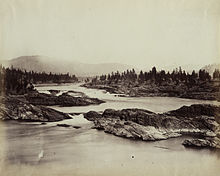
Kettle Falls
The Kettle Falls or Kettle Falls were waterfalls in the northwestern United States in the form of cascades and rapids . The cases were in Stevens County in northeast Washington state not far from the Canadian border.
In the language of the Okanagan , in whose traditional territory the falls are located, the falls were called sx̌ʷnitkʷ (great falls). In the language of the inland Salish they were called Shonitkwu (loud water). In 1940 the falls disappeared in the artificially dammed water of Franklin Delano Roosevelt Lake . Until then, they were one of the most important salmon catches in the northwestern United States. Here the waters of the Columbia broke through quartzite layers that had been deposited by the Missoula floods . The damming tore off the salmon migrations, which were among the largest in North America.
history
Traditional lifestyle
Already before 7000 BC In the 3rd century BC, fishing can be demonstrated in the kettle cases, and since the beginning of the Christian era there has been continuous use by the same ethnic groups. Groups from the areas along the Pacific as well as groups from the inland met here. During the fishing season, up to 14 tribes camped at the falls between June and October and threw their spears or laid out their baskets off Indian Island , an island in the middle of the falls. Only those animals were hunted that could no longer make the transition over the falls and thus could not reach their spawning areas.
Trading posts, missionaries, smallpox
The Briton David Thompson was the first white man to reach the falls on June 19, 1811, which he called Ilth koy ape , after an Indian name for the baskets used for catching. Thompson, who stayed for two weeks, described the falls as a kind of comprehensive rendezvous - this was also the name given to the big hangouts for trappers and fur traders - for news, trade, and settlement disputes. The tribes of the area did not take part in any armed conflict as mediators. In 1825 the Hudson's Bay Company established a trading post near Fort Colvile . French traders named the Colville "Les Chaudières" after the waterfall.
Missionaries used the meeting place for so many groups to promote their religion. In 1838 the Catholic missionaries François Norbert Blanchet (later Archbishop of Oregon City, now Portland) and Modeste Demers (later Bishop of Vancouver Island ) advertised here , for example among the Sanpoil . The Jesuit missionary Pierre-Jean De Smet came to the falls in 1841 and reported that the Indians caught up to 3,000 fish every day. After 1847 the Protestant missionaries disappeared again from the region, but the Catholics extended their activities to the Sanpoil and vaccinated them against smallpox . However, one of the missionary groups from Kettle Falls brought the smallpox up the Columbia, and after that the Sanpoil avoided the mission station at the Kettle Falls.
Development of the area by the whites
In 1845 the Jesuits set up a mission station here, the St. Paul's Mission .
In 1891 a hotel was built over the falls and a speculative bubble arose when the railroad was supposed to stop here. But when the Northern Pacific Railway decided to take a different route via Marcus further north, many of the 300 or so settlers left the area again.
Construction of the Grand Coulee Dam
The waterfalls disappeared with the construction of the Grand Coulee Dam , which began in 1933 , and which dammed the water over 120 m and created Franklin Delano Roosevelt Lake .
In a “ceremony of tears” 8,000 to 10,000 Indians of the affected tribe, the Colville , but also envoys from the Yakama , Spokane , Nez Percé , Flathead , Blackfeet , Coeur d'Alene , Tulalip and Pend d'Oreille mourned the loss of the important place . In addition to the loss of self-sufficiency because the salmon could no longer migrate, of unifying ceremonies and the possibility of organizing large-scale gatherings, graves also disappeared on Indian Island .
Along with the flooding of the Priest Rapids , Celilo Falls and Cascades Rapids further downstream, the damming of the water put an end to the traditional way of life of the Colville reserve residents.
Remarks
- ↑ Guy E. Gibbon / Kenneth M. Ames: Archeology of Prehistoric Native America. To Encyclopedia , Taylor & Francis 1998, pp. 411f.
- ↑ Astrida R. Blukis and Trudy Haversat: Archaeological Excavations at Site 45JE16, Indian Iceland, Jefferson County, Washington, Burial Report , Washington State University 1977th
literature
- Lawney L. Reyes: White Grizzly Bear's Legacy: Learning to be Indian , University of Washington Press 2002
Web links
Coordinates: 48 ° 38 ′ 21.6 " N , 118 ° 6 ′ 34" W.


