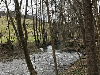
Great Loessnitz
| Great Loessnitz | ||
|
Great Loessnitz (2018) |
||
| Data | ||
| location | Saxony , Germany | |
| River system | Elbe | |
| Drain over | Flöha → Zschopau → Freiberger Mulde → Mulde → Elbe → North Sea | |
| Headwaters | near Großwaltersdorf | |
| Source height | approx. 540 m above sea level NN | |
| muzzle | between Metzdorf and Hetzdorf in the Flöha coordinates: 50 ° 49 '54 " N , 13 ° 8' 9" E 50 ° 49 '54 " N , 13 ° 8' 9" E
|
|
| length | 17.8 km | |
| Catchment area | approx. 65.3 km² | |
| Drain |
MQ |
740 l / s |
| Right tributaries | Little Loessnitz | |
| Communities | Eppendorf | |
The Great Loessnitz is 17.8 kilometers, the second longest tributary of the Flöha .
It rises at Großwaltersdorf about 540 meters above sea level and then runs in a west-northwest direction. Below from Eppendorf to the mouth, the watercourse has carved out a valley cut about 100 meters into the terrain. Between Lößnitztal and the former Metzdorf stop of the narrow-gauge railway Hetzdorf – Eppendorf – Großwaltersdorf, the course meanders in a relatively wide and visibly wet floodplain. The adjoining piece up to the mouth, however, has a significantly steeper gradient if the floodplain is only narrow.
The Kleine Lößnitz, which rises to the southwest of Görbersdorf at 465 meters above sea level, empties from the right about 400 meters above the influence of the Flöha .
Web links
Individual evidence
- ↑ See Lößnitzthal. In: The middle Zschopau area (= values of our homeland . Volume 28). 1st edition. Akademie Verlag, Berlin 1977, p. 114.
- ↑ See Kleine Lößnitz. In: The middle Zschopau area (= values of our homeland . Volume 28). 1st edition. Akademie Verlag, Berlin 1977, p. 113.
