Great Galtenberg
| Great Galtenberg | ||
|---|---|---|
|
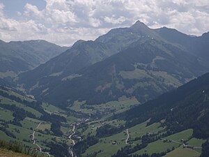
The Große (left) and the Kleine Galtenberg (right) seen from the Wiedersberger Horn (from the north-west), in front of the Greiter Graben |
||
| height | 2424 m above sea level A. | |
| location | Tyrol , Austria | |
| Mountains | Kitzbühel Alps | |
| Dominance | 5.3 km → Schafkopf | |
| Notch height | 513 m ↓ Steinbergjoch | |
| Coordinates | 47 ° 20 '12 " N , 11 ° 58' 33" E | |
|
|
||
|
Great Galtenberg from the Gratlspitze |
||
The Great Galtenberg (also only Galtenberg ) is with a height of 2424 m above sea level. A. the highest mountain in the Alpbach valley and the Kufstein district in Tyrol . It lies in the Kitzbühel Alps and is located on their northeastern foothills, at the southern end of the Alpbach valley. The Alpbach ski area is located opposite the Galtenberg on the Wiedersberger Horn and the Schatzberg . Its summit lies entirely in the municipality of Alpbach . Due to its exposed location and easy access, it is a very popular panoramic mountain.
Surroundings
Southwest of the great Galtenberg lies the 2318 m high small Galtenberg , with which it is connected via the Galtenbergjoch . In the northeast the Heimjoch , also in dialect Mareitkopf ( 2004 m ), and in the east the Torkopf ( 2116 m ), are upstream. Towards the southeast, the mountain slopes down with a pronounced ridge to the Otto-Leixl-Hütte ( 1911 m ).
Tourist development
The Große Galtenberg can be reached from the Alpbach suburb of Inneralpbach via several routes.
- From the Luegergraben from the Bubenkapelle ( 1060 m ): The path first leads away from the parking lot into the forest, then steeply in several serpentines towards the former Alpenkreuz hunting lodge . Then there is a slight incline on the long ridge southwards towards the summit pyramid. At the end of this long ridge comes the final but easy ascent over the north face to the summit.
- From Greiter Graben at the former Leitner inn ( 1143 m ): The path leads along the forest road southwards, past the Greitalm ( 1320 m ), over the Farmkehr-Niederalm ( 1521 m ), up to the Farmkehr-Hochalm ( 1771 m) ). From there a marked hiking trail leads to a fork in the road just above the hut. If you choose the path to the left (towards northeast), you can get to the above-mentioned path relatively quickly (between the ridge and the north face). If you follow the path to the right (heading south), you will pass several small ponds and then you will come to the Farmkehr-Pfanne , at the end of which is the Galtenbergjoch . From the yoke, the path leads in a few minutes, with a beautiful, slightly exposed ridge hike, to the summit.
Literature and map
- Alpine Club Map 1: 50,000, Kitzbüheler Alpen West, No. 34/1, ISBN 978-3-928777-55-1 .
swell
- Alpine Club Map 1: 50,000, Kitzbüheler Alpen West, No. 34/1, ISBN 978-3-928777-55-1 .
- Federal Office for Metrology and Surveying
Web links
Individual evidence
- ↑ a b AMAP Austria. In: www.austrianmap.at. Retrieved January 4, 2017 .


