Great Artesian Basin
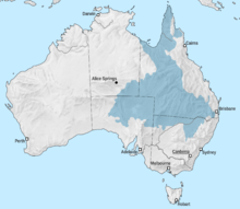
The Great Artesian Basin (Engl. Great Artesian Basin ( GAB )) in Australia is one of the largest underground aquifers worldwide and covers 1,711,000 square kilometers. This corresponds to about 23 percent of the area of the Australian continent .
Territory and use
The basin is one of the main elements of the geology of Australia and encompasses large parts of the state of Queensland , the southeast corner of the Northern Territory , the northeastern part of South Australia and the north of New South Wales . The water reservoir extends from the Great Dividing Range to Lake Eyre . Its longest extension is 2,400 kilometers from Cape York in the north to Dubbo in the south and 1,800 kilometers from the Darling Downs in the east to west of Coober Pedy .
The freshwater resources are estimated at 64,900 cubic kilometers. This corresponds to a volume of water the size of the basin and an average water depth of 38 meters and thus 130,000 times the volume of the port of Sydney . It was discovered by European settlers in 1878 and extends roughly below a quarter of the Australian continent . This discovery triggered a huge economic boom in terms of livestock , as the water can be widely used for livestock. The underground water is pumped up using wind turbines, diesel and electric pumps. In many places the water has a very high salt content.
The rock deposits in which the water reservoir is contained were formed 100 to 250 million years ago. The reservoir rock , a mighty sequence of sandstones from the Triassic , Jurassic and Cretaceous , forms the subsurface of the Great Artesian Basin in several wide-span, merging bowl-shaped structures. The sandstone formation, which is up to 3000 meters thick, is sealed at the top by a series of layers of fine-grain sea sediments, while the older rocks (older than Jura) form the seal at the bottom.
origin
Especially in the east in the area of the Great Dividing Range found a wide area on the surface an upcoming porous rock layer. There rainwater can penetrate into the ground and slowly penetrate west and south as groundwater . In the west and northwest, precipitation is low due to the desert climate, so that hardly any new groundwater is formed there. In the central area it can emerge as if from an artesian spring . The undrawn groundwater would reach the springs in the south of the basin in the area of Dalhousie Springs , Lake Eyre , Lake Frome , Bourke and Bogan River after about two million years . Another theory is based on a fossil groundwater basin , similar to the Libyan desert .
Risks
The abstraction of groundwater poses some problems. In the event of overuse, the lowering of the groundwater level also leads to the ingress of (salty) seawater, making the groundwater inedible for decades for human consumption and unusable for irrigation in agriculture. Another problem with the aquifer is increasing pollution from leaks in cesspools, landfills, and emissions from industrial plants and fracking chemicals.
The Great Artesian Basin Coordinating Committee (GABCC) not only coordinates water abstraction by federal and local governments, but also monitors it.
Cultural meaning
Long before the European colonization of Australia , Aborigines used the natural spring outlets of the Great Artesian Basin. They were considered reliable sources of water in times of drought, when other sources dried up. The water outlets were and are of great importance for traditional Aboriginal culture: many stories of the dreamtime and drawings involve the sources of the Great Artesian Basin and their placement along travel paths. Some of the sources appear in the myths of the Aborigines and thus significantly support the spiritual and cultural beliefs of the local communities.
The springs are also still valuable for the wild animals living here.
Individual evidence
- ↑ a b The Great Artesian Basin. (PDF; 227 kB) In: Queensland Department of Natural Resources and Water. Accessed April 14, 2019 .
- ↑ GM Mudd: Mound springs of the Great Artesian Basin in South Australia: a case study from Olympic Dam . In: Springer (Ed.): Environmental Geology . tape 39 , no. 5 . Berlin / Heidelberg March 2000 ( article online [PDF; accessed April 9, 2013]).
- ↑ Lance Endersbee: The Plutonic Waters of the Great Artesian Basin (PDF), accessed April 14, 2019
Web links
Coordinates: 25 ° 0 ′ 0 ″ S , 143 ° 0 ′ 0 ″ E


