
Strasbourg belt of fortifications

The Strasbourg fortress belt (also known as the Great Fortress of Strasbourg ) was a defensive ring consisting of 19 forts that ran extensively around the city of Strasbourg . The individual forts were built as Biehler's standard forts after Alsace-Lorraine had been incorporated into the German Empire in 1871 . Today the fortifications, some of which are still preserved, are linked by the cross-border bike path to the forts .
history

After the Franco-Prussian War , Strasbourg became part of the German Empire with the Peace of Frankfurt in 1871 . The siege of Strasbourg in 1870 had severely damaged the city's old fortifications. The Prussian army wanted to develop Strasbourg into one of the most important fortresses in the west of the German Empire and thus protect it from an attack by France. In addition to an inner fortification wall around the city, a network of a total of 14 forts was laid out over a wide area between 1871 and 1882. One goal was to keep an attacker at a distance from which he could not shoot the city center directly. Therefore, the individual forts were arranged in a circle with a radius of 8 to 9 kilometers (the maximum range of guns at that time was approx. 5 kilometers), which corresponded to the maximum range of contemporary cannons with a certain safety margin. The area around Kehl was also included in the fortress, three of the forts were built in the years 1874–1878 to the right of the Rhine ( Fort Kirchbach , Fort Blumenthal and Fort Bose ).
In addition to the 14 forts, five smaller forts ( intermediate works ) were built between 1885 and 1890 . During this time, the concrete walls had to be reinforced because of the invention of modern artillery ammunition (keyword: explosive grenade crisis ). To further fortify the city, the fortress of Kaiser Wilhelm II was built from 1893 about 20 km west of Strasbourg .
During the First World War , Strasbourg, in contrast to Mulhouse, was not threatened by any attack by the French, and consequently no fighting took place at the forts. The war material was gradually withdrawn to the front, and the forts were then partly used as prisoner-of-war camps. Like all former German fortifications on the French side - - After the war, was as Strasbourg back to France, the forts were renamed, it was about from the Fort Moltke the Fort Rapp . Some of the works continued to be used or even expanded by the French army; among other things, Fort Ducrot was included in the Maginot Line and it was expanded and rebuilt according to the knowledge of the 1930s.
The three forts on the German side were destroyed after the First and Second World Wars. Most of the other structures are now covered with greenery and only four fortresses are open to the public.
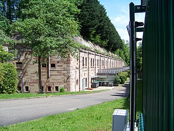
Building description
The fortresses were built according to the uniform fort system by Hans Alexis von Biehler and all have a similar construction. They consist of an upstream weapon station, a powder magazine, barracks, kitchens, the hospital, casemates and guard houses.

Fort Ducrot

Fort Rapp, entrance

Fort Frère, moat

Away Uhrich

Ouvrage Frere glue
Fort Foch


List of forts
Originally, the forts were named after German generals and politicians. After the First World War, with the exception of the three forts on the right bank of the Rhine, they were renamed to the names of French generals and marshals.
| Surname | Name until 1918 | local community | country | Construction year | public | Geographic coordinates |
|---|---|---|---|---|---|---|
| Fort Rapp | Fixed Moltke | Reichstett | F. | 1874 | Yes | 48 ° 38 ′ 26 " N , 7 ° 45 ′ 20" E |
| Fort Ney | Festivities Fransecki | Strasbourg La Robertsau | F. | 1876 | No | 48 ° 38 ′ 20 " N , 7 ° 47 ′ 47" E |
| Fort Blumenthal | Auenheim | D. | 1878 | No | 48 ° 36 '21.8 " N , 7 ° 50' 40.6" E | |
| Fort Bose | Neumühl | D. | 1878 | No | 48 ° 34 '30.4 " N , 7 ° 51' 27" E | |
| Fort Kirchbach | Sundheim | D. | 1878 | No | 48 ° 32 '50.4 " N , 7 ° 50' 25.4" E | |
| Fort Hoche | Festivities Schwarzhoff | Strasbourg-Neuhof | F. | 1879 | No | 48 ° 29 ′ 39 " N , 7 ° 46 ′ 9" E |
| Away Uhrich | Festivities Werder | Illkirch-Graffenstaden | F. | 1876 | No | 48 ° 30 '40 " N , 7 ° 43' 22" E |
| Fort Lefebvre | Festivities from the Tann | Geispolsheim | F. | 1876 | No | 48 ° 31 ′ 36 " N , 7 ° 41 ′ 27" E |
| Fort Joffre | Fixed Crown Prince of Saxony | Lingolsheim | F. | 1875 | No | 48 ° 33 '32 " N , 7 ° 39' 55" E |
| Fort Kléber | Festivities for Prince Bismarck | Wolfisheim | F. | 1875 | Yes | 48 ° 35 ′ 23 " N , 7 ° 39 ′ 45" E |
| Fort Brother | Festival Grand Duke of Baden | Oberhausbergen | F. | 1875 | Yes | 48 ° 36 '54 " N , 7 ° 40' 50" E |
| Fort Foch | Fixed Crown Prince | Niederhausbergen | F. | 1875 | No | 48 ° 37 '38 " N , 7 ° 41' 34" E |
| Fort Ducrot | Festivities Podbielski | Mundolsheim | F. | 1882 | Yes | 48 ° 38 ′ 24 " N , 7 ° 42 ′ 16" E |
| Fort Desaix | Fixed roon | Mundolsheim | F. | 1875 | No | 48 ° 38 '17 " N , 7 ° 43' 27" E |
| Surname | Name until 1918 | local community | country | Construction year | public | Geographic coordinates |
|---|---|---|---|---|---|---|
| Ouvrage Neuf - Empert | Zwischenwerk 1 New - Empert | La Wantzenau | F. | 1889 | No | 48 ° 38 ′ 10 " N , 7 ° 49 ′ 18" E |
| Ouvrage Ney - Rapp | Intermediate work 2 Fransecky - Moltke | Reichstett | F. | 1890 | No | 48 ° 38 ′ 22 " N , 7 ° 46 ′ 30" E |
| Ouvrage Frère - Kléber | Zwischenwerk 3 Grand Duke of Baden - Bismarck | Oberhausbergen | F. | 1889 | Yes | 48 ° 35 ′ 55 " N , 7 ° 40 ′ 30" E |
| Ouvrage Joffre - Lefebvre | Zwischenwerk 4 Crown Prince of Saxony - Tann | Lingolsheim | F. | 1889 | Yes | 48 ° 32 ′ 46 " N , 7 ° 40 ′ 41" E |
| Ouvrage Uhrich - Hoche | Intermediate plant 5 Werder - Schwarzhoff | Illkirch-Graffenstaden | F. | 1890 | No | 48 ° 30 ′ 2 " N , 7 ° 45 ′ 2" E |
Bike path to the forts
The cycle path to the forts has been running along the 19 forts since 2011 (French: Piste des forts , this name is sometimes also used in German). This cross-border circular cycle path is 85 km long, with around 20 km on the German side.
The route largely circles Strasbourg and crosses the Rhine twice , over the Pierre-Pflimlin Bridge and the Passerelle des Deux Rives . On the German side, the cycle path leads through the Kehler villages of Auenheim, Neumühl and Sundheim; On the French side, the route runs past Illkirch in the south, along the Breusch Canal , the Rhine-Marne Canal and the Rhine-Rhône Canal , in the north it goes to La Wantzenau and through the Robertsau Forest.
See also
Individual evidence
- ↑ a b The cycle path to the forts on www.kehl.de
- ↑ a b Strasbourg and Alsace fall to the German Empire at http://www.landeskunde-baden-wuerttemberg.de/
- ↑ The fortress belt of Strasbourg on www.de.strasbourg.eu
- ↑ Cycling along old fortresses in Baden Online, August 20, 2013